Day 5: Needles, CA to Kingman, AZ
Distance: 70 miles
Climbing: 5,100 feet
Today we finally left California, which is always a landmark event. Needles, for those of you who’ve never been there, is right on the Colorado River. To get on the road to Oatman, we could have just crossed the river on a bridge right there in town, but that wouldn’t have been following Old 66. You see, before the construction of Hoover Dam, it was impossible to build a bridge or ferry landing at Needles because the river would flood. So the bridge that the Joad family from The Grapes of Wrath and other early Route 66 travelers crossed on was located about 14 miles south of Needles, where the river passed through a canyon narrow enough that it could be bridged.

So, off we headed south on the National Trails Highway and Route 95. After a little more than six miles, we came to a spot where the old road was still accessible, although it was too sandy for us to actually ride on it. We did stop and go a short distance, though, to where we could see some original asphalt and the curved concrete berms that are a sure sign of genuine archaic road construction. We also looked at a big washout that exposed the entire construction of the road like a sliced layer cake – you could clearly see the macadam and the asphalt layers.

Then it was onto I-40 to ride past the old arched white bridge that used to take Route 66 across the Colorado but which now supports only a gas pipeline. After passing that, we exited the Interstate and started a long, gradual climb on the east side of the Colorado River toward the town of Oatman.

To get to Oatman, we had to climb from about 600 feet to over 2,700 feet. The scenery was different than what I remember from five years ago. The roadrunner-and-Wile E. Coyote mesas and cacti were still plentiful, but I guess that the drought that hit Arizona means that there are fewer wildflowers. We also didn’t see thousands of butterflies, as we did five years ago.
We finally reached Oatman in time for lunch, where I had a great buffalo burger. Anurang bought me lunch to make up for putting a heavy rock in my rear saddlebag when we stopped to look at the old road and then letting me haul it uphill for more than 10 miles. He also made me promise not to write about it. So you didn’t just read this.
As for Anurang, he was plagued with “hotfoot” all day, which is a cycling condition that comes from shoes that are too tight and pedals that press against your foot in the wrong spot. He asked Lon for advice and the first thing that Lon suggested was that he move his cleats back as far as possible from the ball of his foot. When we looked at his shoes in Oatman, we discovered that he had a second set of holes where he could screw the cleats in, but we couldn’t get one of the bolts out of his shoe because it was so worn that it wouldn’t work with an allen wrench. Lon said he could fix it when we got to Kingman, so Anurang simply had to grin and bear it.

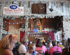
Oatman, by the way, is a former ghost town that has been re-born as a tourist trap. I wasn’t impressed with the place five years ago, and it hasn’t improved since then, although there’s more RV parking.

So, right after eating lunch, we started climbing again toward Sitgreaves Pass, which is at 3,500 feet. This climb gets pretty steep in places, but it’s both beautiful and interesting as you pass abandoned mines and cool rock formations. I think that the day was quite a bit warmer than five years ago, and a fairly steady tailwind made it feel even warmer on the climb.

The descent from Sitgreaves starts out conventionally, with lots of curves and switchbacks, but eventually it straightens out and you just roll like a ball bearing straight down to the valley floor. This takes a long time, and Anurang got a bit ahead of me, as he is a superb descender.
From there, it was a long, straight ride across the valley floor (sorry, I have no idea what valley floor) to the other side, where we started climbing up a canyon toward Kingman and reconnected with I-40, although we didn’t have to get on it this time. A few miles before town, we got to take a “bike-hike” option that involved crossing some rail tracks on foot so that we could ride on a traffic-less old alignment. I remembered this as being really special five years ago, and it was nice this time, but not as pretty as I remembered.
Tomorrow promises to be an interesting day as we ride to Seligman, which is the town where Arizona’s Route 66 revival got its start.
Road Movie
Just as I started to try filming this yesterday, the road got a little bumpy…
Day 4: Ludlow, CA to Needles, CA
Distance: 108 miles
Climbing: 3,394 feet

At dinner tonight, Sandi Taylor from Route 66 magazine said that I looked wiped, and I’m sure I did. My eyes feel like I’ve been wearing contact lenses made of sandpaper. It was another day of “abundant sunshine” in the desert, although it was the wind that actually demanded our attention. Like the proverbial “close talker,” it had a way of getting in your face.
But, the day started well enough. Anurang and I had time the night before to go for a short walk to some of the ruined buildings of Ludlow and still get to bed early, so we had a good night’s sleep. Last night was our only night of rooming together on this trip – a result of there being a limited number of motel rooms in Ludlow.
Honestly, I don’t know how those of these towns that do survive manage to do so. Ludlow, I guess, is still on the interstate, and it seems to attract a lot of truckers. Close to a dozen of them were lined up across the street when we started this morning. So many of the other towns that used to flourish on this route, though, have withered away bit by bit – losing a school, a church, gas stations, motels, cafes. Because this is a desert, you can see the remains long after the people and the business have vanished. One (former) town that we passed by today, Goffs, used to have a thriving store and café; we ate there five years ago. The owner simply vanished one day about four years ago without telling anyone where he was going. We had a rest stop in the parking lot, and I looked through the window – there were still packages of food on the shelves.
Another iconic Route 66 spot on today’s ride, Roy’s Café, in the town of Amboy, is completely shut up, as are the motel and school. Anurang was able to buy more stamps at the post office, though.
Although it was cold when we went to breakfast in the morning, it had already warmed up a bit by our seven-ish start time (we had to fix a flat rear tire on my bike that Anurang noticed before we went to breakfast) I didn’t bring a jacket – just arm warmers, knee warmers, and a thin wool layer under my PBP jersey (we both wore those today). Within an hour, the arm and knee warmers went in the handlebar bag. Overall, though, the temps stayed fairly moderate until the afternoon.
Anyway, we started out with a short, easy climb and not much wind. The first 20 miles were both easy on the legs and extremely scenic. You can see a long way in the desert, and there are always interesting mountains and volcanos on the horizon. The trains – I heard today that something like 250 of them pass through here each day – are a constant presence. Sometimes they’re close by and sometimes they’re so far in the distance that you can see a mile-long train all at once. At one point in the afternoon, we watched as two trains 10 miles away looked like they were on a collision course; even though you knew they weren’t going to hit each other, you couldn’t take your eyes away as they seemed to rush right at one another.
As the morning progressed, the wind started to pick up a little, and our progress slowed just a bit. Lon caught up to us by this point. I asked him when he had first gotten interested in Route 66; was it during his Race Across America days? “Well, that’s when I first rode here,” he said, “but I actually started to get interested later, in the late 80s, when we were doing PAC Tours here.” In those days, it was hard to get information about the original Route 66 alignments, and Lon spent a lot of time piecing it all together before he did the first Route 66 Pac Tour. The one guidebook he had, he said, when he started, contained no specific directions at all, but things like “turn left at the old store and drive a ways before making a right turn.”
After we passed the Amboy crater (last erupted in 1945, it says on our route card; maybe better pedal a little faster) and Roy’s, a van pulled up in front of us and started filming and interviewing Lon. Anurang was a bit behind us at this point. After the van finally pulled ahead, we ran into Bob Moore and Sandi Taylor from Route 66 magazine waiting by the side of the road. Bob was also the ace support crewmember on our tour five years ago. We chatted with them for a few minutes and then continued on to the next rest stop, which was at the top of a hill.
Now the wind was starting to get serious, and our average speeds dropped accordingly. It was also considerably warmer; I really felt like I was riding in the desert now. It seemed to take a long time to get to the lunch stop, too. “This should be a milkshake stop,” I announced to Anurang. Alas, it was not to be. The truck stop/café in Essex was a really nothing more than a large convenience store. I was hungry enough that it didn’t really matter that much however.

We’d already noticed that my tire looked like it had lost some more air while we were getting to lunch, so we’d stopped to pump it up a bit. I pumped it up even more at lunch in the hope that it was a really slow leak. After a few miles, though, it was clear that I needed to change the tube again. This time we went over the tire minutely to try to determine if there was something stuck to the inside that caused both flats. Couldn’t find anything, though. I can see my bike from where I’m typing this now, in fact, but I’m too tired to get up and see if it still has air in it. I guess I’ll know whether we’ve fixed it by tomorrow.
We finally made it to Goffs (the town that formerly had a store), and things got decidedly easier after that. Almost all of our climbing was behind us, for one thing – Needles is at least 1,000 feet lower (on the Colorado River) than Goffs. Also, the wind would be slightly less onerous as we curved around to the south.
The pavement was, for the most part, quite ridable all day – the worst road we had to ride was I-40, which we had to take for the last 10 or so miles into Needles. Five years ago, this was a section that Lon and I had missed because Lon wanted to scout out a possible dirt road that he thought might at one time have been 66. I think he concluded that it was just a dirt road that more or less followed the train tracks.
Rollling into Needles, I insisted on a stop at DQ for a root beer float, still feeling a bit cheated about not getting my milkshake lunch I guess. “I’m not really hungry,” Anurang said, “but I’ll hang out with you while you eat one.”
We both enjoyed our floats before doing the last mile to the motel.
Newspaper Story
Cyclists Get Their Kicks on Route 66
They used a different photo in the Desert Despatch.
Day 3: Barstow, CA to Ludlow, CA
Distance: 52 miles
Climbing: 1,700 feet
A short day today, but it was not necessarily an easy day. Breakfast was on Pac Tour at the Carrow’s across the street (OK, not every restaurant can be an authentic Route 66 diner), but Anurang and I just had oatmeal and toast because we planned to eat again 22 miles down the road at the Bagdad Café.
Leaving Barstow, we followed a frontage road next to I-40 for nearly three miles before hopping onto the interstate itself for a couple of miles. Then it was back onto the frontage road, which was Route 66.
The terrain was high desert – very reminiscent of the area southwest of Mono Lake that we ride on the Eastern Sierra double century. Low scrub and sand. We stopped briefly at Daggett because there was a post office, but it wasn’t open yet. Daggett also has a “Pioneer Cemetery,” which looked like it was located down a sandy road about midway between Old 66 and I-40 – too far for a detour, anyway, although I was curious what such a place would be like out here in the desert where things take so long to decay.
We were riding with Leon from South Africa. Traffic was light, the wind (coming from the northeast) was light, and the road was fairly good at this point, so we made pretty good time as we passed the mirror solar plant to our north. I kept stopping to try to take pictures and then having to try to catch up again.
Eventually, they waited for me and we all rode together toward Newberry Springs, which is the site of the Bagdad Café. Lon had shown the movie Bagdad Café at the motel in Barstow the night before, but we missed that while we were looking for dinner. The wind steadily got stronger as we went, and I realized that the oatmeal wasn’t cutting it so I ate my “emergency” Powerbar. Finally, we saw Newberry Springs (making a quick stop at another post office about a mile from the café).
As we pulled into the parking lot for the café, Jim Hlavka, one of the tour’s crew members, told us that the proprietors had somehow gotten the idea that we were going to all be eating breakfast there, when in fact almost everyone had stuffed themselves silly at Pac Tour’s expense 22 miles earlier. “They even had another cook come in,” he said, “so I ordered another breakfast, even though I needed it like another hole in the head,” he said.
Anurang and Jim (and Leon) to the rescue. “I’m starving,” I told the waitress, and she looked like she wanted to hug me. Instead, she put the theme from Bagdad Café on the jukebox for me. We all ordered the Pan San (basically a 2 x 2 x 2). Leon got a milkshake and Anurang and I had lemonades and then decided that splitting a milkshake might not be a bad idea.
Anurang found a copy of the Desert Dispatch, the Barstow paper, which apparently has some of the same stories as the Victorville paper. Sure enough, we found an article about our ride written by Tatiana Prophet (great name). I looked at the large photo and then looked at Leon sitting across from me and then looked at the photo.
“Leon, is that you?” I showed him the paper.
“No.”
“Anurang, doesn’t that look like Leon?”
“Dude, are you sure that’s not you?”
“Uh…” Leon looked again more closely. “I’m famous!” This meant that we had to give him the newspaper. Although I’m not recognizable, I’m in the photo as well, with my back to the camera as I get ready to park my bike in front of the Route 66 Museum.

After a long, leisurely lunch at the Bagdad, we three left with Lon to tackle the toughest section of the day’s riding: more wind (although more from the northwest than the northeast now) and truly dreadful pavement that lasts for most of the next 20 miles. Traffic was next to non-existent – everyone was racing along on the interstate to the right of us – so we meandered all over the road looking for the smoothest parts, with me keeping a close eye on my mirror to try to spot any cars that might be approaching from behind. Generally, I could see them while they were still more than a mile away. The farther we went, the fewer they were.
The scenery was gorgeous, I thought, with not a cloud in the sky and hills and mountains surrounding us, with one snow-capped peak poking up from the south that might have been San Jacinto. We passed a few utterly ruined gas stations and motels – some looking as though the proprietors had just walked away from them one day to let the desert do its slow work.
We’ve been paralleling the rail lines since we entered Cajon Pass, so there have been lots of trains. One was coming from the other direction not too far to our left, so we all waved and pulled on imaginary whistles. The engineer tooted his horn for us to the meter of “Get Your Kicks on Route 66.”
A couple of times we passed lava beds, which, from a distance, looked almost like abandoned asphalt themselves. I wondered where the volcano that disgorged all the lava might be and got a partial answer when we passed Pisgah Crater, which clearly was a volcano. It looked just like the one I made in elementary school, in fact.
Did I mention that the road was rough here? Boy, if anything weren’t fastened down properly on your bike, this road would be the way to discover it. It also apparently was enough to make my bike computer’s display freeze. (I got a tip from another rider, Gary Bass of Tennessee: Put the bike computer in your pocket during the rough stuff). So, I really had no idea how far I’d gone after an hour. I looked at the route sheet and it said there was a rest stop after 20 miles. That was a good thing, because I had left the Bagdad Café without thinking to put any food in my pockets and, of course, I’d already eaten my emergency Powerbar during the morning. Fortunately, I did not bonk, and the rest stop showed up on schedule.
Somehow, I managed to get my bike computer to unfreeze. For you less-technical types, I’ll just say that I used a special technique involving pushing all the buttons as quickly as possible until something happens. Turns out the computer was recording all along, so I didn’t lose any miles. I didn’t realize that the timer needed to be re-started, too, though, so I lost 2.6 miles that way. I hate that timer.
Anurang announced that the next, and last, 10 miles would be the roughest of the whole day, based on his memory from five years ago. Lon agreed and said that it was like riding across 2 x 4’s. I couldn’t tell whether Lon was kidding or not. He’d be a hell of a poker player.
He was kidding. The last 10 miles were actually on much better road, by and large, with a downhill and slightly better wind. We stopped at one point to mess around with the video feature on my camera with so-so results.
And now we’re in Ludlow, which would truly be a one-horse town if they could find a horse. There are only eight motel rooms here, so for this one night Anurang and I are sharing a room. The alternative would be to get driven back to Barstow for the night and then ferried back here in the morning (which in fact is what I did five years ago).
Tomorrow promises to be our most challenging yet as we try to ride 105 miles to Needles (right on the border with Arizona) with what is supposed to be significant wind and a fair bit of climbing. Five years ago, we had a strong tail wind, and Anurang tells me that we did it in less than six and a half hours. I don’t think that will happen this time…
Day 2: San Bernardino, CA to Barstow, CA
Distance: 80.50 miles
Total climbing: 4,500 feet
I don’t think that it really feels like you’re on a tour until you’ve done your second day; you’re probably more than a normal day’s ride from where you started, and you’re starting to settle into your routine. Well, I’m not quite settled, but I’m getting there.
Also, this second day of Route 66 really is the first one where you can begin to see abandoned remains of the old road. It also is the first day where you ride in the desert, which sets the tone for so much of what is to follow. I would guess that we’ll be in some kind of desert or other for most of the rest of the way to and through Texas.
But first, back to Rialto and the Wigwam Motel. Anurang and I walked to a nearby store for snacks and picked up some 66 schwag at the Wigwam office on the way back. He got some pins and I got a Route 66 sticker for the back of my ukulele.

A while later, a group of us walked a short way to the Grand Opening of a Mexican Seafood Restaurant. It was a pretty big place, but there were only two customers sitting at a booth watching a big-screen TV play some kind of dance program on a Spanish language station. Loudly. I probably would have turned around and left it was so loud, but instead we sat down and had a good cheap dinner. I had tamarindo and pozole, which was a giant bowl of soup (although I ordered the “small” size) with hominy (“hommy” in the menu’s description) and big chunks of pork. Lynette, sitting across from me, had the same thing, although as an apparently temporarily lapsed vegetarian she added a lot of cilantro and onion garnish.

After dinner, back at the hotel, I struggled with the supposed high-bandwidth connection and eventually uploaded some stuff using my brand new Apple modem. I can kind of understand why Apple no longer builds a modem into its notebooks, but is their add-on USB modem really only capable of 28Kb? Anyway, it was excruciatingly slow, and I ran out of time on my $5 phone card before I got all the photos uploaded that I wanted to, even at fairly low resolutions. Thank goodness Judith was around to send me the list of access numbers that I forgot to bring with me.
I finally finished all of that a little while after 9:00 and went to bed. I’d been up since 4:30, so I was ready for a good night’s sleep. And I did sleep pretty well, too, until my phone rang at about 4:00 AM. I stumbled across my Wigwam to answer it. The guy on the other end said something I didn’t understand so I asked him to repeat it. He did, and it was an unsavory proposition. I hung up and tried to go back to sleep. The phone rang again after a few minutes so I just ignored it. Later, I heard that several other people got phone calls as well.
I was about asleep at 4:30, when there was a knock on my door. Now this was starting to creep me out. This was not the wigwam experience I wanted. I looked through the peephole and there was a burly guy with a shaved head and moustache who looked like he’d come straight from the penitentiary to bang on my wigwam door. He was saying something urgent that I couldn’t understand but that might have been someone’s name. My first reaction was to shut the deadbolt. I looked at the wigwam windows. They were kind of small, but were they small enough? I waited a while and looked again. He appeared to have left.
So, I went back to bed and slept like a baby.
Of course not. Instead, I checked my e-mail (nice note from Judith about the typos in the previous day’s post), fixed some more typos, and discovered that the outlet I’d plugged my fancy GPS bike computer into was apparently not working. I switched the computer to a different outlet so that it could at least charge for a couple of hours.

Finally, at 6:30 we walked to a nearby donut shop for “breakfast.” Three old-fashioned donuts later, I was ready to get on my way.
Lots of traffic on Foothill Boulevard as we left the Wigwam motel behind – I guess we hit the rush hour. As we rode through what must have been northern San Bernardino, traffic stayed pretty heavy until we veered left onto 5th Avenue and started a very long, steady climb toward Cajon Pass. One way you could tell that this used to be Route 66 was by the numerous down-at-the-heels motels. This was also the first time we saw “Route 66” painted onto the asphalt.
Anurang and I came to a freeway underpass where they were doing some construction and there was a posted detour. We tentatively rode past the barrier and approached the flag man to ask whether it would be OK if we rode through. The guy said “No, you have to go around,” so I dutifully turned around and rode back to the barrier, where I saw Lon and a half dozen or so other riders approaching. “They say we have to go around,” I said and “it can’t hurt to ask.” I was all set to start down the detour when I heard Anurang whistle loudly and motion to us all to come through. After we rode through the small construction site, which saved us about a mile (based on what some other, less-fortunate riders told us), I asked Anurang how he got the man to change his mind. “I asked his supervisor,” he said. “You can’t waste your time talking to the flunky.”
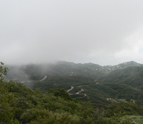
Cajon Pass is big, long, scenic and, on this day, full of dark clouds. People driving old cars, especially the dustbowl migrants, must have dreaded getting over it. Now, it has a freeway (I-15), several rail lines, and a frontage road that includes what used to be Route 66. In some places, I think, the old road has just completely disappeared beneath the freeway. We started the pass by riding a detour past one of these sections where the road was completely gone.
We then got on the left side of what was once the first divided highway in America. I think this was built in 1930. The other side is “out of service” and blocked off with barriers, although I did ride on a short stretch of it. Eventually, though, that ran out, and we were all forced to get onto I-15 at about mile 22 shortly after a nice rest stop on the disused side of the old road.
Riding on the Interstate can never be described as fun, but it doesn’t seem particularly dangerous if there’s a big enough shoulder and if you are careful about things like off ramps. The noise is awful, though, and on a pass like this one the trucks are all in the rightmost lane where it’s pretty hard to not notice as they go by. Fortunately, as we started climbing, the trucks passing us were going more and more slowly. Anurang and I had left the rest stop with Lon and another rider, Leon from South Africa. As we climbed, with Lon out of the saddle on his one-speed Quickbeam, Anurang dropped off the back and I decided to see if I could hang with the other two all the way to the summit at 4,400 feet.
At one point, Lon stopped to pick up a rubber tie-down strap and drop it in his rear bag. I’d forgotten how he likes to collect stuff. After he picked that up, I started noticing lots of similar straps, but Lon’s was the only one I saw that had the hooks still attached to both ends.
Lon told me a story about a RAAM (Race Across America) in the early 80’s where Michael Secrest was 3 minutes behind him as they climbed this same pass on the interstate. The race rules stipulated that you get off at the Summit Inn and get on the frontage road. Lon did this, but Secrest stayed on the interstate. When he saw Lon riding on the frontage road, he realized his mistake, but there was no way he and his crew could turn around on I-15, so they had to go miles to the next exit before his crew could ferry him back up the hill to the Summit Inn to get back on the course. In all, he lost an hour, and he didn’t catch back up to Lon until somewhere in Utah.
I was keeping a close eye on my bike computer at this point to see how much farther before we reached 4,400 feet, but I wasn’t keeping a close-enough eye, because 3 miles went by after the rest stop before I remembered that I had stopped the timer there in an effort (futile, for all I know) to conserve battery time. I guess I have to accept that I’m just too absent-minded to ever reliably remember to start the damn thing up again, so I’d better not ever stop it.
However, it turned out that Lon’s route card was wrong – the summit was actually at 4,190 feet. If I’d looked closely at the picture I took of the summit five years ago, I would have known this. Still, I wasn’t disappointed to finish climbing 210 feet early. The sky had been very cloudy all morning, but it seemed to clear almost instantaneously as we crested the grade. It would stay sunny the rest of the day.
The Summit Inn is a coffeeshop, basically, with a jukebox, lots of junk on the walls (including, of course, Route 66 junk) and great waitresses. I hear it has great milkshakes, too. They serve ostrich burgers, buffalo burgers, ostrich-egg omelettes, and all the usual coffeeshop fare as well. Anurang was still a ways back, so Lon and I sat at the lunch counter and ordered. Anurang finally showed up and complained again about having accidentally changed all of the menus on his camera to Chinese (or maybe Japanese?). So, I fixed that for him and he had to buy me lunch.
I ordered potato salad with my burger, which I realized was probably a bad choice when Lon and Anurang got their french fries. The waitress overheard me bemoaning my decision, though, and brought me a small plate of fries on the side for free. Another reason I liked the Summit Inn is that they let me plug in my bike computer so that I could charge it up enough to last all the way to Barstow.
When we finally left the Summit Inn, it was COLD. I suddenly remembered how hot the inside of the Inn seemed when we entered. Now I was shivering in the parking lot while waiting for Anurang to pay our bills.
I was expecting some kind of a big downhill after all that (admittedly easy) climbing from San Bernardino, but instead we had a very gradual descent that, with the addition of a lot of wind from the west, didn’t seem like descending at all. After just a few miles, we got stopped behind a long line of cars waiting for some roadwork, where we also caught up with several more of our riders.
The rest of the ride into Victorville was fairly ordinary, although I did note some Joshua trees early on in the descent and, when I looked back, gorgeous views of the snowcapped San Gabriel and San Bernardino mountains.
Victorville was clearly a “Route 66 Town” – lots of signs and so on. It’s also the home of a Route 66 Museum, which I missed five years ago because we started that trip on a Saturday and the museum is closed on Sundays. They sold a lot of stuff to Pac Tour riders on this Monday, though, and there were also a photographer and reporter from the local Victorville paper taking pictures and interviewing people about the trip. I discovered that I don’t like people pointing big cameras at me and taking pictures when they think I’m not looking.
The museum was nice, although I admit that I sometimes have trouble getting excited about the stuff that passes for authentic Route 66 memorabilia. I did like the Route 66 aloha shirt, but they only had it in size small. The folks at Kaleo Café would have dug it.
From Victorville, it really starts to feel like a ride through the desert. I noticed that my camera battery was running low in the museum (probably too many flash photos), so I didn’t take many pictures from this point on. Also, we had a stiff crosswind from the west as we traveled mostly north, and I didn’t want to stop and get left behind by the other folks in my group. I saw quite a few abandoned motels and former gas stations, though, as well as some businesses that seemed to be hanging on just barely.
Mostly, I was riding with Lon, Leon, and Anurang, and all of us took fairly long turns at the front at one point or another. I stopped about half a mile before the last rest stop to walk a few yards into the desert to “shift fluids” and noticed half of a green Coke bottle poking out of the sand. I mentioned this to Lon at the rest stop and he pointed to a pile of tin cans a few yards from where we were parked. “Go see if any of them have holes punched in them,” he said. That’s a sign that they are older than 1965. Things thrown away in the desert last a long time, you know. I did walk over to the cans, and the first one I picked was a pre-1965 specimen. It was thoroughly oxidized (an antiques expert would say that it had developed a lovely patina) but you could almost make out the lettering. I couldn’t tell what it was though, really, and not even whether it was a soda or a beer or a can of juice.
This desert riding brought back all kinds of PAC Tour memories; every tour I’ve been on with them has crossed a desert, and it’s always been one of the most memorable and unique parts of the trip. I noticed how dry it was, of course, and my eyes started to feel a little scratchy, but it wasn’t really a hot day. I left my knee and arms warmers on all afternoon (in the morning I actually wore wool tights and a wind breaker as well).
Very gradually, we shifted our direction from due north to a more northeasterly heading toward Barstow and the cross wind became more of a tail wind. I couldn’t see the downhill, but I was riding in a big gear, so it must have been there. Lon got in front at one point when there were about half a dozen of us. He hit a short little uphill stretch without slowing down, and Anurang and a couple of other guys dropped off the back. The other two eventually caught back up, I think, but I didn’t see Anurang again until we reached the hotel in Barstow – another “Route 66 Town,” at least on Main Street.
I figured that the desert would be a good place to do laundry, so I washed some jerseys, shorts and underwear. Tomorrow will probably be an even better place to do laundry since it’s such a short ride into Ludlow (just 50 miles).
I discovered the motel has wireless access, but once again I couldn’t get it to work (neither could Anurang). I jumped on with the modem just long enough to send Judith an e-mail with my whereabouts (some of our motels have changed from the previously published list).
Then I started writing this until Anurang came over to see if I wanted to get dinner. We walked down Main Street and found a Dollar Store where I could get some clips for hanging clothes, a Sharpie for putting notes on my route card, and some twine for hanging up clothes. Then we went to a Radio Shack where Anurang bought a camera cable so he doesn’t have to keep borrowing mine, and I got a new phone card (used up the old one trying to upload pictures to Flickr this morning).
Dinner was Italian food at that atmospheric place behind the Shell Station. Bruschetta will forever be a punchline for Anurang and me after that meal.
Day 1: Santa Monica, CA to Rialto, CA
Distance: 78.46 miles
Total climbing:2,795 feet
I believe this first day of the tour is almost entirely urban cycling, which makes it unique on this tour. We rode from one end of the Los Angeles basin to the other. That it was Easter Sunday, I think, made the trip a lot more pleasant than it would have been on most days. The route we took for the first 15 miles or so, along Santa Monica and then Sunset Boulevard, would have been next to impossible on a normal weekday.
Breakfast was at a donut shop across the street from our hotel, and people were tapping on the door at 5:28 am. Anurang and I didn’t eat a lot there because we knew that we would want to stop after about 25 miles for a proper breakfast in Pasadena. We actually started riding at 6:30 – first heading down to Ocean Avenue on Arizona Street, which is one block north of Santa Monica Boulevard (Route 66) but a lot nicer for bicycles (although traffic throughout L.A. was unusually light).
After messing about with photos at the Will Rogers Highway plaque, we headed east on Santa Monica Boulevard to begin the journey to Chicago in earnest. Of course, I forgot to reset my odometer like I was supposed to do.

We got as far as West L.A. before I insisted that we detour for a couple of blocks so that I could see whether the apartments I lived in during the 80’s were still there (they were, largely unchanged, although the neighborhood seemed to have a few more big ugly buildings in it). I wonder if people who live in L.A. are as aware of how much the place has changed in the past couple of decades as I am when I make my rare visits. Then again, I’ve changed a fair amount in that time as well.
Lon and some other folks caught up to us before we reached Beverly Hills. A few things that struck me about Santa Monica Boulevard: The pavement is in terrible condition for most of the way through Santa Monica and West L.A. It’s by and large an ugly stretch of town. As you near the Mormon Temple and Century City, there’s a lot of roadwork going on. It seems like they’re re-configuring the street – seemingly to make it more car-friendly.
Santa Monica Boulevard doesn’t exactly give a great impression of Beverly Hills, either. You do get to see City Hall and the Police Station, but most of the ch-chi stores are one block south on Wilshire.
Sooner than I expected, we reached La Cienega for our big left turn and a short but significant climb up to Sunset Boulevard. I got to watch Lon tackle what was probably a 15% grade on his Rivendell Quickbeam singlespeed. He seemed to take it in stride. I was regretting the 70 miles and 7,000 feet of climbing I had done the day before. That may be the single steepest block on this whole trip.
I don’t want to give the impression that there wasn’t any traffic at all – there was, but it was really light compared to what you’d normally find, so we were able to travel along Sunset in a relaxed manner. Someone had asked the night before whether we would see the Hollywood sign. I kept an eye out for it, and I knew that it would be visible from Gower Avenue if from anywhere, but the clouds were too low and obscured it completely. We did see Griffith Park Observatory, though. Although we were watching for it, we missed Barney’s Beanery.
Sunset eventually curves south toward downtown L.A. as it travels through Echo Park and past Dodger Stadium. We skirted east of downtown L.A. and Union Station before turning east again toward Pasadena. Somewhere in this next stretch, we had a rest stop at a local park and also passed the Santa Anita racetrack. No one seemed to want to stop, so I tried without much success to take a picture of it while holding my camera over my head (it was behind an ivy-covered fence).
When we got to South Fair Oaks Blvd, in South Pasadena, we started a long, very gradual climb toward Colorado Boulevard, which I believe is the street they have the Rose Parade on. Although today’s route was sort of “flat,” meaning there were no big climbs, there were enough stretches like this one to give us almost 2,800 feet of elevation gain. It probably feels flat if you have a tailwind (which is typical), but we actually had a slight headwind and crosswind during the early part of the day. The tailwind didn’t really kick in until the last hour or so.
Anyway, one block past Colorado Ave. (where Route 66 turns right) on Fair Oaks is a restaurant called Russell’s that my friend Eric introduced us to during this same ride five years ago. Lon, Anurang, myself and a couple of other folks decided to stop for a proper breakfast. What sold Lon on the idea, I think, is that the place opened in 1930. We’re big on history during this Pac Tour.
Nice breakfast of blueberry pancakes.
From there, it was basically back onto Colorado Boulevard for many miles of Pasadena. For the rest of the day, we were going east toward San Bernardino, but staying just a few miles south of the San Gabriel Mountains that so effectively trap the smog in the L.A. basin during the warmer months. Today was not particularly warm, but it was muggy and overcast. Arm warmers came on and off, as did my new Route 66 windbreaker.
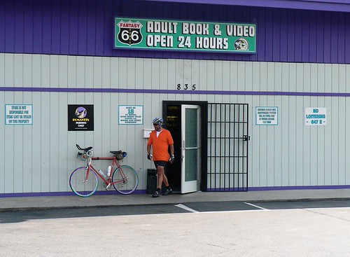
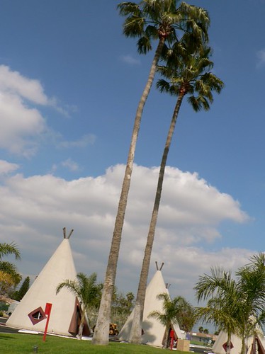
Eventually, we wound up on Foothill Boulevard as we passed through town after town. Through most of L.A., there is very little roadside mention that one is traveling on Historic Route 66. I think I saw two signs – one of which was outside our hotel in Santa Monica. But as you travel through these foothill towns – Rancho Cucamonga, Monrovia, Azusa, Duarte, Fontana, etc., you start to see more and more signs referring to Route 66. More than one Route 66 car wash and Route 66 real estate office. I took pictures of a few representative Route 66 businesses, including the notorious “Fantasy 66 Adult Book and Video,” which is not far from our final destination today – the Wigwam Motel in Rialto. Well, they say they’re in Rialto, but they are definitely just past the city limits sign for San Bernardino.
I remember passing this place five years ago, but it was rundown at that time, and it wasn’t recommended as a place to actually stay. That year, we actually detoured five miles off the route to stay at a modern motel in San Bernardino. This Wigwam (there’s another one in Arizona that we’ll be staying in, too) is under new management, however, and it’s really quite wonderful. My only complaint: I couldn’t get the high-speed Internet access to work for more than a few moments. Not sure whether that was my fault or theirs.
Day 0: Hanging Out in L.A.
We drove down I-5 last night under stormy, bruised skies that finally let loose as we crossed Tejon Pass. By the time we reached Santa Monica around 8:30, the rain was pouring. It had stopped by the time we checked into our motel, though.
When I got up the next morning, the streets were still damp and the skies were overcast, but it didn’t look much like rain. I have good Internet access here, so I was able to check the radar as well. I walked across the street to Coogie’s Café, but it wasn’t going to be open until 7:00, so I decided to ride down Santa Monica Blvd until I found a Starbucks or something better.
After just a couple of miles, I saw several cyclists coming the other way, and as we passed I realized that they were Route 66 riders. I did a U-turn, caught up to them, discovered that it was Lon Haldeman and the Crew and let Lon know where I was going. This was the first time I’d seen Lon since the finish of Paris-Brest-Paris three years ago. He reminded me that I needed to be back in time for the 3:30 rider meeting.
After turning back around again, I rode to the Main Street Mall, which is just a couple of blocks from Ocean, which is the last street before the Pacific Coast Highway (PCH). Sure enough: a Starbucks. By now it was 6:54 or so, but Starbucks didn’t open until 7:00. I figured I’d better wait.
Some people were gathering in front of Starbucks with various street-fair paraphernalia. “Hi,” said one young woman. “Are you here for Earth Day?”
“No, last I checked Earth Day wasn’t until April 22,” I said. I could have said “I’m here to FORGET about Earth Day.”
“Well, we’re here to celebrate the Earth.”
I was there to celebrate coffee and a maple scone, but Starbucks, bucking its corporate image, wasn’t opening on time. I watched the Santa Monica police arrest and handcuff a vagrant with a BMX bike across the mall from the café while I waited.
Finally, one latte and scone later, I got back on the road and headed north on PCH. Even at 7:30 in the morning, there was a lot of traffic, and it was moving fast. The shoulder had an irritating habit of suddenly deciding to disappear as well. This was worse than I remembered from my youth, but I managed to make it to Malibu, where things improved somewhat. The big hill at Pepperdine was certainly a blast from the past. Finally, I reached the turnoff for Latigo Canyon Road.
Latigo Canyon Road was my first. My first Hill. Back when I began riding a bike somewhat seriously a little more than 20 years ago, Latigo Canyon Road was the first real climb I attempted after reading about it in a book of bike routes. I still remember going up it the very first time and suddenly thinking “You’ve never done anything this hard before.” I’d probably never done anything really hard before that climb, actually.
Now, I’m certain that I have not ridden Latigo Canyon Road for at least 18 years. But I’ve always maintained a shamelessl sentimental fondness for it because it was my First. I didn’t pretend to myself that I remembered a lot about it, but I had a couple of recollections. And I often wondered what it would be like to ride up it today in my dotage.
Well, it turns out that I remembered almost nothing about Latigo Canyon Road. And even if I had, there’s been a huge amount of development along it over the past couple of decades. Still it was a great climb. I saw several other cyclists on it and not that many cars. It goes up 2,000 feet from PCH, drops 200 after a false summit, and then climbs back up to 2,000. I really enjoyed it. It twists and turns and twists some more.
I managed to find my way down the other side to Mullholland Highway easily enough and then started east toward where my friends Randall and Sharon live. Passed the Rock House, which I remembered from my Santa Monica Mountains riding days (it’s a big motorcyclist hangout), and enjoyed very light traffic for quite a few miles.

I did get lost when I tried to follow the directions that Randall had sent me and, as the morning slipped away, I began to get a little nervous about how long I was going to be out. I finally found their house at around 11:25. It’s a very nice house, too, and I had to have a quick tour of course.
Randall gave me directions to Stunt Road, which is only a couple of minutes from their house. My meager store of memories of Santa Monica Mountains routes included the information that once one climbed Stunt Road it would then be basically downhill all the way back to Santa Monica. Randall said that the climb was about 4 miles and 1,300 feet. I also remembered that it was a tough climb to do on a hot day, which this, fortunately, was not. The sun did come out a bit, though, as I made my way slowly up the hill. By this time, I’d already climbed over 5,000 feet for the day, which is probably more than I should have been doing on the day before starting a PAC Tour, but tomorrow is supposed to be almost completely flat, so what the heck. The climb was, in fact, just over 1,300 feet, but after turning at the top onto Saddle Rock Rd, it kept going up for a little while. It also became very foggy. I was at 2,400 feet now and basically riding in the clouds.
Soon enough, though, it started heading mostly down, and before too long I came to a road called Tuna Canyon. This sounded vaguely familiar, so I decided to head down it. It was so foggy, though, that I wasn’t positive I was heading down toward the ocean. Heading down away from the ocean would have been a Very Bad Thing. My new bike computer has a compass heading feature, though, and this reassured me. I was even more reassured when I could see the ocean after the fog cleared a bit.

Tuna Canyon was an amazing descent. Long, steep, and with sweeping views of Santa Monica Bay and the Pacific below. It dropped me onto PCH just south of Malibu. Traffic was terrible but, again, I cheated death and managed to get back to the motel just before 2:00, which gave me time to have a shower and grab some food before the 3:30 rider meeting, which took an hour.
Now I’m just waiting for my nephew Jeff to show up so we can go to dinner at Gilbert’s El Indio.
Update: We went to Gilbert’s and then to Westwood for ice cream cookie sandwiches.
Bon Voyage
Doing some last-minute packing today — Anurang and I are driving down to Santa Monica this afternoon.
The weather looks good (down there) so far.
Tomorrow I’m planning to do a ride in the Santa Monica Mountains for old times’ sake and to see some friends who bought a house there last year. If you’re going to ride for 29 days in a row, why not make it 30?
Yesterday, had a farewell lunch with the folks at work, and Adrian gave me this lovely handmade card.

Test Post
This is a test post.

When it comes to posting on Route 66. It’s important not to get stuck.
We will be leaving Santa Monica on April 16th. It’s anyone’s guess whether the unrelenting rain will stop by then. I assume the weather’s likely to be somewhat nicer in Southern California than it is here, but I checked last night and it’s raining there this weekend. Well, I expect it’s got to rain at some point on this ride, but it’s always lousy to start in the rain. That’s the kind of thing I only do on a PAC Tour.
At this point, I’m still working on the logistics of what I’m going to bring on the ride and how I’m going to update this weblog each night.
