Day 5: Needles, CA to Kingman, AZ
Distance: 70 miles
Climbing: 5,100 feet
Today we finally left California, which is always a landmark event. Needles, for those of you who’ve never been there, is right on the Colorado River. To get on the road to Oatman, we could have just crossed the river on a bridge right there in town, but that wouldn’t have been following Old 66. You see, before the construction of Hoover Dam, it was impossible to build a bridge or ferry landing at Needles because the river would flood. So the bridge that the Joad family from The Grapes of Wrath and other early Route 66 travelers crossed on was located about 14 miles south of Needles, where the river passed through a canyon narrow enough that it could be bridged.

So, off we headed south on the National Trails Highway and Route 95. After a little more than six miles, we came to a spot where the old road was still accessible, although it was too sandy for us to actually ride on it. We did stop and go a short distance, though, to where we could see some original asphalt and the curved concrete berms that are a sure sign of genuine archaic road construction. We also looked at a big washout that exposed the entire construction of the road like a sliced layer cake – you could clearly see the macadam and the asphalt layers.

Then it was onto I-40 to ride past the old arched white bridge that used to take Route 66 across the Colorado but which now supports only a gas pipeline. After passing that, we exited the Interstate and started a long, gradual climb on the east side of the Colorado River toward the town of Oatman.

To get to Oatman, we had to climb from about 600 feet to over 2,700 feet. The scenery was different than what I remember from five years ago. The roadrunner-and-Wile E. Coyote mesas and cacti were still plentiful, but I guess that the drought that hit Arizona means that there are fewer wildflowers. We also didn’t see thousands of butterflies, as we did five years ago.
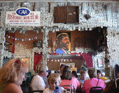
We finally reached Oatman in time for lunch, where I had a great buffalo burger. Anurang bought me lunch to make up for putting a heavy rock in my rear saddlebag when we stopped to look at the old road and then letting me haul it uphill for more than 10 miles. He also made me promise not to write about it. So you didn’t just read this.
As for Anurang, he was plagued with “hotfoot” all day, which is a cycling condition that comes from shoes that are too tight and pedals that press against your foot in the wrong spot. He asked Lon for advice and the first thing that Lon suggested was that he move his cleats back as far as possible from the ball of his foot. When we looked at his shoes in Oatman, we discovered that he had a second set of holes where he could screw the cleats in, but we couldn’t get one of the bolts out of his shoe because it was so worn that it wouldn’t work with an allen wrench. Lon said he could fix it when we got to Kingman, so Anurang simply had to grin and bear it.

Oatman, by the way, is a former ghost town that has been re-born as a tourist trap. I wasn’t impressed with the place five years ago, and it hasn’t improved since then, although there’s more RV parking.

So, right after eating lunch, we started climbing again toward Sitgreaves Pass, which is at 3,500 feet. This climb gets pretty steep in places, but it’s both beautiful and interesting as you pass abandoned mines and cool rock formations. I think that the day was quite a bit warmer than five years ago, and a fairly steady tailwind made it feel even warmer on the climb.

The descent from Sitgreaves starts out conventionally, with lots of curves and switchbacks, but eventually it straightens out and you just roll like a ball bearing straight down to the valley floor. This takes a long time, and Anurang got a bit ahead of me, as he is a superb descender.
From there, it was a long, straight ride across the valley floor (sorry, I have no idea what valley floor) to the other side, where we started climbing up a canyon toward Kingman and reconnected with I-40, although we didn’t have to get on it this time. A few miles before town, we got to take a “bike-hike” option that involved crossing some rail tracks on foot so that we could ride on a traffic-less old alignment. I remembered this as being really special five years ago, and it was nice this time, but not as pretty as I remembered.
Tomorrow promises to be an interesting day as we ride to Seligman, which is the town where Arizona’s Route 66 revival got its start.

Leave a comment