Day 14: Las Vegas, NM to Santa Rosa, NM
Distance: 78 miles
Climbing: 2,400 feet

For more photos, be sure to check Flickr.
If yesterday (Day 13) was about the sorts of things that make this trip occasionally challenging, then today was like winning the PAC Tour lottery.
The lights came back on at 11:30 last night, so I got up and posted what I’d written and uploaded my pictures. I then went back to sleep. I think I probably slept close to nine hours last night, which is about two more than I’ve been averaging on this trip. As a result, I felt a lot better when I got up today, and felt pretty good throughout the day, although the cycling conditions might have had something to do with that.
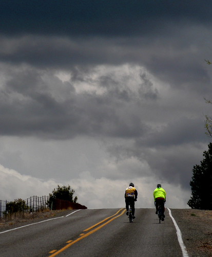
When I looked outside at first light, the sky still seemed pretty threatening, but by the time we walked across the road for breakfast it was starting to clear somewhat, although it was still chilly. Lon, Anurang, and I left the motel with the intention of checking out downtown Las Vegas, which is about as unlike the other Las Vegas as it could possibly be.
The town bills itself as the best-preserved example of western boomtown architecture in the west, and I believe them. The center of town is full of the lovely Italianate buildings such as a well-to-do person would have wanted circa 1900 to 1910. Many buildings were constructed of native stone (and there’s some nice stone around here) and then faced with bricks brought in on the railroad.
Once we got rolling, it was clear that the forecast north wind was blowing steadily, and what seemed like arduous hills on the way into town melted beneath our wheels. I believe we were the last riders to leave Las Vegas, thanks to our sightseeing detour, but we almost caught up to Joe and Phil before the first rest stop at about 27 miles. Very light Saturday morning traffic on Highway 84 and beautiful New Mexico scenery also made the miles go more pleasantly.
At one point, I made them stop and look behind us: the mountains we came over yesterday were covered in snow. Lon said he heard that it snowed in Glorieta Pass yesterday, in fact. Well, New Mexico needed the rain, so I’m glad we were able to do our part to end the drought.
We continued on Highway 84 through the town of Dilia, which is where five years ago Lon, myself, Don Norvelle, and Gary Bass tried to find the great lost shortcut to Colonias. Although Lon had a note about this possible old alignment on the route card, I don’t think he expected anyone to try taking it, since he hadn’t had a chance to scout it out properly since 2001 and still wasn’t sure where the road actually was.
You can probably get most of the story from my 2001 Route 66 website, but the short version is that that we got lost when we took a dirt road from around Delia and finally got directions from some ranchers who were out looking for a lost puppy (which Lon found for them). One of the ranchers gave Lon his card and said he could help him figure out the route, but Lon misplaced the card a couple of times and was never able to get back in touch with the guy.
So, we were keeping an eye out for a road that might be the correct one branching off to the left toward Colonia. The alternative was to continue straight south on 84, make a left turn when we hit I-40, and then take that east to Santa Rosa. Lon’s theory was that the Delia-Colonia road would eliminate this right-angle route and shorten the distance like the hypotenuse of a triangle.
Lon suspected that County Road #40 might be a candidate, although it was quite a few miles past Delia. I noticed what I thought was the dirt road we took five years ago, and I kept an eye out for other possibilities, but I didn’t see anything very promising until Lon pointed out what turned out to be #40 switchbacking over a distant low hill to our left. When we got to the road, we stopped to wait for Anurang and decided that we might as well see where it seemed to go. We were still a few miles shy of the second rest stop, so we also flagged down Joe and Phil before they passed us, and told them to let Rosemary know not to wait for us.
County Road #40 headed due east from Highway 84 for about a mile before reaching some ranch buildings at the base of the hill, and the first few hundred yards were actually paved. A sign said that it was called Moon Ranch Road. When we got to the ranch, a pickup truck pulled out, so we stopped to talk and see if we could find out where we were going.
The rancher was tall, lean, and dark, with a black moustache and a cowboy hat. I got the feeling he was a bit suspicious of us at first, but as Lon explained what we were doing, his attitude softened a bit to where I think he just thought we were harmless eccentrics. Yes, he said, the road did go through to Colonia; you just kept going until you hit pavement at a t-intersection. If you turned left, you’d go to Colonia, and if you turned right, you’d go to the interstate, near Stuckey’s.
This sounded promising, so we continued on. Anurang and I could see that Lon was excited about possibly filling in this part of the Route 66 puzzle, but it was a lovely ride in and of itself. We went for over an hour without seeing a single vehicle, although we did scare a few cows.
The road was well maintained, but it was basically hard-packed dirt and good-sized gravel. It wound up and down, following the contours of the land, until we finally did reach the promised asphalt road. Sure enough, a left turn would take you down to Colonia, and the paved road was called the Colonia Road. We probably should have taken the left turn to see what would happen, but instead we decided to go right and see how far it was to the interstate. I was pretty convinced that the road we were on used to be Route 66 before 1937, but neither Lon nor I was sure how it related to the road we had been on five years previously.
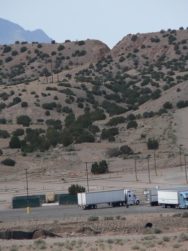
This paved road was really nice with, again, almost no traffic. At one point Lon wondered whether maybe this was the road we had reached Stuckey’s on five years ago, since it reminded him a lot of where he found the puppy, but it was pretty clear that the asphalt had been there longer than that. Eventually, we topped a rise and saw the telltale semis in the distance. A little closer, and we could see Stuckey’s, which was off to our left. We pulled in there to get some snacks and drinks, since we had been almost 50 miles without any support.
Inside Stuckey’s, I asked the lady at the cash register if the road to Colonia went anywhere after Colonia. Oh yes, she said, to Moon Ranch. I said we’d come on the Moon Ranch Road but wondered if the old road had used to go straight, perhaps to Delia? She wasn’t sure, but she asked another woman who worked there, and she said that the road used to go straight but that now it was private property.
So, we got on I-40 and rode, quickly, downhill and with the wind at our backs, to Santa Rosa. One complication: the interstate was being resurfaced, so there was no clear indication where the shoulder was for most of the way to town. This was a bit disconcerting, but we managed to get in all right.
Anurang and I grabbed a grilled cheese sandwich at the motel’s restaurant (the worst fries on Route 66 said Anurang) before he, Lon, and Franz took the van back to Colonia to see if any sign of a road still existed north from there.
Apparently not.
Day 13: Santa Fe, NM to Las Vegas, NM
Distance: 70 miles
Climbing: 4,400 feet
For more photos, be sure to check Flickr.
What can I say about today? We had all the ingredients for a classic PAC Tour experience: bountiful headwind, hard rain, and a seemingly endless series of rolling hills. But it wasn’t all good.
We got out of Santa Fe fairly quickly and after a few miles got onto I-25, which would take us all the way up and over Glorieta Pass. This was all climbing, but it wasn’t too steep until the last couple of miles. The scenery was beautiful and, although there were plenty of clouds in the sky, we had relatively nice weather, for which I was grateful. I heard later that it snowed at the pass after we went through.
The top of the pass was at mile 18, after which we descended gradually toward the town of Pecos. I say “we,” but I lost track of Anurang early during the climbing. This descent was one of the most pleasant parts of the day’s riding — not that there was a lot of competition for that distinction.
There was a rest stop near the Pecos Monument Ruins, which jogged my memory from five years ago. This time, though, our rest stop was across the street from the visitor’s center.
After this rest stop came a series of gradual climbs for 19 miles or so until we got to the turnoff for the village of San Jose. There was another rest stop here as well as an “explorer” option to go one mile down a gravel road to see an abandoned original Route 66 bridge. When I got there, several guys were standing around wondering whether this really was the right turn for the bridge. The rollers and the wind (now coming from the east) were slowing folks down enough that they were reluctant to gamble on going one extra mile down the road. This seemed crazy to me, so I went down the road, (which has apparently been paved sometime in the past five years), dodged two big black barking dogs who chased me, found the bridge, and took some pictures of it as well as of the local church.
Eventually other riders, including Lon and Anurang, showed up. I left the rest stop with Lon and some others (Anurang was still messing around in San Jose), and started on what would prove to be the hardest section of the ride, most of which I ended up riding by myself.
The clouds had been getting more threatening, and soon after leaving the rest stop I started to feel some sprinkles. So, I put on my rain jacket. I road a little farther and decided to put on my rain pants, booties, and long gloves. Now the rain started to come down in earnest, so I was glad I had all this stuff. And, as Franz had observed, it was starting to “chill off” (must be a Canadian expression). Staying warm was never a problem, though. Sometime during all of this wardrobe adjusting I got behind Lon and never saw him again.
After a while, the rain stopped and I took off my rain jacket but left on the pants and booties since they’re harder to take on and off and I didn’t seem to be in any danger of overheating. Now, I concentrated on just getting up the hills. These were especially awful because as soon as you got to the top of one long series of them, you would see the next series waiting for you. “What have I done to deserve this?” went through my mind more than once. Making matters worse, it was now well past lunch time and I hadn’t been eating or drinking enough (a common occurrence when the weather’s bad). I made myself slow down and eat a couple of PowerBars, which eventually perked me up a bit.
Finally, after about 64 miles, I came to a gas station mini-mart, which also marked the turn to Las Vegas. It seemed like it was starting to rain again, so I decided to pull in and get some more food and put the rain jacket back on. I had an egg salad sandwich, some water, and a Hershey bar. When it went out to get ready to leave (now it was getting really cold, Anurang pulled up in great spirits and announced: “I’m going to have a hot dog!”
By now it was raining hard. I left Anurang to his hot dog and started on the last six miles of the ride, some of which, at least, were downhill. The rain was bouncing off the pavement; I think it might have been semi-hail. When a drop would catch me on the lower lip, it hurt like heck, so I tried to keep my head down and just concentrate on getting into town.
I was really, really, really glad when I finally found the Santa Fe Inn. And they have an excellent free wireless connection. Anurang rolled in after I’d showered, followed shortly by Bruce Fields and then a smiling Susan Rosenblatt, who gets my nomination for gutsiest rider. Leon told me how he nearly froze while fixing a flat tire. Because he’s faster, he managed to ride in the rain for a couple of hours at least.
Anurang and I went to dinner with Lon and the crew at an excellent restaurant that I think is associated with the hotel a little after five o’clock. Not long after we got our entrees, though, the power went out.
In fact, the power is still out. I’m sitting in my room in the dark typing this on battery power. Wireless? Gone. The phone doesn’t work either. And it’s still raining.
The good news is that once this storm peters out sometime tomorrow morning, we’re forecast to have a tailwind to push us south to Santa Rosa. And the forecast for Sunday is even nicer, with sunny skies and a west wind that could get us to Tucumcari. Let’s just hope the power comes on before tomorrow morning….
Day 12: Albuquerque, NM to Santa Fe, NM
Distance: 74 miles
Climbing: 4,300 feet

For more photos, be sure to check Flickr.
Today was all about La Bajada. We left Albuquerque around 7:30 after a great breakfast at the Village Inn. (Anurang, who is sitting next to me right now says “What is the point of writing the blog; I’m giving you all the information. And not only that, you make fun of me. I could sue you for hurting my feelings. Is tomorrow supposed to be a beautiful day?” He’s still going on, but I’ll stop now.)
Before we left, I said to Lon: “Anurang and I have decided that we’re going to hammer today.”
Lon took this in stride. “It’s about time.”
Albuquerque is a big city, so it takes quite a while to get out of it. I was kidding about hammering, but we did start out at a pretty good clip behind Franz, who is a strong rider. Our group of four or five eventually caught up to another group of four or five as we fought the rush hour traffic through town.
Thunderclouds were much in evidence, and at one point I could see where it was raining up ahead of us (in fact, it rained on Jay, who is one of our fastest riders). After 18 miles, we reached the town of Benalillo, where it had clearly just rained. I counted only one bike amongst our group that had fenders, so it was pretty messy and my lovely wool Swobo jersey got spotted with mud on the back.
Shortly after this, I decided that I’d had enough of “hammering,” so Anurang and I dropped off the back of the paceline and settled into a more manageable speed: “sweet sixteen” as Anurang said. Unfortunately, the wind, which has been mostly from the south since I can remember, was now blowing from the north, so “sweet sixteen” soon became “slow thirteen.” But at least I could see something more than the rear tire of the guy in front of me.
After a couple of miles, another paceline of a few riders caught up to us, so we followed them for a while. Scott Alperin, who was on the tour five years ago as far as Albuquerque, and who joined us today to ride as far as Amarillo, was pulling these guys. After resting at the back for a while, I went up to the front to give Scott a break for a couple of miles before we reached the first rest stop at Algondones.
From here, we got on I-25 heading toward Santa Fe. Lon caught up to us on this stretch, so I rode with him for most of it. We stopped after passing an Indian casino in San Felipe to take a photo of “The Big Notch,” which was the way the old road used to come over the hill. We were riding a series of very big rollers that gradually gained us some altitude.
After 15 miles of the interstate, Lon and I climbed over a concrete barrier to get on a nice frontage road that took us the last couple of miles up to where the van was parked for the second rest stop. This was the last stop before La Bajada, so Lon warned everyone who was planning to do that option to make sure that they had enough food and water to last them several hours. Most of the fast guys we’d ridden with early in the morning had already left, but we (Lon, Anurang, Phil, and myself) waited around until all the riders had reached the rest stop, especially Susan, who Lon knew wanted to do La Bajada.
A little bit about La Bajada: It supposedly means “the descent” in Spanish, although we would be climbing it. As a route, it’s centuries older than Route 66. In fact, Route 66 only went through Santa Fe before 1937, so La Bajada’s tenure as a Route 66 byway accounts for only a small portion of its history. It’s never been paved. Going up it now, it’s hard to imagine how Model T’s ever managed it, although I suppose it’s changed a lot since those days. It’s a volcanic escarpment so there are lots of big igneous rocks everywhere on the “road,” which is more like a steeply switchbacking hiking trail than a former highway.
Lon, Anurang, Phil, Susan, Scott and I all started together. We broke up into three separate groups pretty quickly: Phil and I were at the front of the regular La Bajada route, Lon and Anurang decided to take an older route to the top that forked off after about a third of the climb, and Susan and Scott were a bit behind Phil and me.
Lon always makes La Bajada sound like a highway to hell when he describes it to people, but it’s really not that bad if you’re willing to walk a few sections. I had to walk more sections than I recalled from five years previous, but I think I rode more than half of the climb, as did Phil. The views were stunning.

Once you reached the top of the plateau, the riding became much easier: basically across a grassy plain with a two-track hard-packed (mostly) dirt road. Phil and I rode until we got to the point where I reckoned the route that Lon and Anurang were on rejoined ours and stopped there to eat and drink a bit while we waited for them and for the other two. They showed up in about 10 minutes, and Scott and Susan arrived not much later.
Now we had about seven more miles across the plateau before a “steep gravel downhill” (I live for those – not), after which we met the SAG truck driven by Rosemary.
I confess: I was getting tired at this point. Riding through all that sand and gravel takes a lot of spinning, and spinning isn’t one of my strong suits. But we still had 10 more miles of riding, some of which were uphill. Fortunately, the wind had now changed back to its normal southern self, so it wasn’t too long before we entered Santa Fe.
After getting cleaned up, I had just enough time for a quick walk around the plaza and to upload some photos at a wireless-enabled café across the street before meeting my sister-in-law and her husband for a really nice dinner in town.
The forecast for tomorrow is rain, and they could really use it here. My ideal would be for it to rain a lot – wherever we aren’t. We’ll see tomorrow, I guess, when we climb Glorietta Pass – the highest point on this trip.
Day 11: Grants, NM to Albuquerque, NM
Distance: 78 miles
Climbing: 5,000 feet
For more photos, be sure to check Flickr.
I woke up at 4:00 this morning thinking, “Did I charge the bike computer?” I had no choice but to get up and see if I had.
I hadn’t. What’s worse, it wouldn’t turn on. It had been acting up during the previous day – shutting off at random – but I’d been able to re-start it each time. Now it wouldn’t do anything.
This irked me. You see, this was an extravagantly expensive (by my standards) GPS-based bike computer that purports to tell me (based on satellite data) how fast I’m going (not very, is usually a good guess), how far I’ve gone, what direction I’m heading, my current altitude, time of day, elapsed time, and calories burned. This last would be more useful if it simply displayed in milkshake units.
Anyway, it wasn’t displaying anything. I blamed myself for letting a sexy technology seduce me away from the keep-it-simple ethos of the true randonneur. Who am I to mock those with busted aero wheels and broken STI shifters, when I have this satellite thingie on my handlebars?
Then I looked in one of my water bottles, and that upset me as well. Yuk! And I don’t have any brushes with me to clean them or my CamelBak, which is also starting to look a bit dodgy in the tube.
And my knees were very sore yesterday after our ride and were still a bit sore when I woke up this morning.
As I was telling Anurang how all this stuff conspired to keep me awake after I woke up at 4:00 this morning, and how it put me completely out of sorts, he laughed. “This is the Jim I love!” he said. “It’s just like you are before a double.” OK, I’m glad someone finds panicked Jim lovable at least.
And yet, I had a great day. After breakfast at the Grant’s Café (not bad, but I probably didn’t order enough; just French toast and cream of wheat), I hurried back to my room to call Garmin tech support to see if they could miraculously bring my computer back to life once they came online at 8 Central time. After half an hour on hold, during which I somehow managed to finish getting ready to go, I was connected to a tech support guy who gave me the magic reset button combination.
Voila: working bike computer. It had even charged a bit while it was seemingly dead. The tech guy had suggested that I download newer software to correct possible “anomalies,” but of course I have a Mac, and they don’t support Macs yet (later this year). And I don’t have a USB cable for the bike computer. Then it occurred to me: What about that cable that Anurang had bought at Radio Shack in Barstow that actually didn’t fit his camera (we were guessing)? Turns out it’s the right size for the bike computer, and he has a Windows laptop. So, sometime in the next few days we will try to do an upgrade.
I asked Lon about spare water bottles, which he had, but decided to go with just my own good one and the CamelBak for now. I can mail order some cleaning stuff tonight.
As for my knees, I did ice them some last night, and I’ve been taking my anti-inflammatory twice a day. I even did some yoga stretching this morning. I also resolved to stay out of the big chain ring as much as possible today – to just ride easy and give myself a rest if at all possible.
When we rolled out at 8:00, there was a bit of wind, but it was light enough not to make life miserable, and although it did pick up a little bit later in the day, it was pretty steady from the south, and we were heading east. So that helped.
It also helped that took us through some of the most scenic parts of the trip. Almost immediately after leaving Grants, we were passing more black lava fields – this time dotted with Chula cacti in bloom. The temperature was perfect and the skies blue with just a few puffy clouds here and there (this will probably change soon from what I gather).
I had left with Anurang, Franz, and our Scottish friends (this was the last day they’d be riding with us for a while, if not forever, as they’re not doing our northern detour toward Santa Fe and expect to be two days ahead of us at least as far as Amarillo). Lon pretty quickly caught up to us.
We were on quiet country roads without much traffic. This was Indian country for the most part. We stopped to look at a Whiting Brothers gas station, at an old steel bridge from 1941, and at Santa Maria Mission. I remembered a lot of this from our trip five years ago, although the order of things had become jumbled in my mind.
As was the case five years ago, the stone and wood carver named Frederico was not in his workshop when we passed, which I think disappointed Lon. You could tell even from the outside of his property that it must be a pretty amazing place.
After a stop in New Laguna Pueblo for water and food, we proceeded on what Lon says is one of his favorite parts of the old road. It really was lovely and, yes, Owl Rock does look like an owl, although it could have as easily been called Ewok Rock.
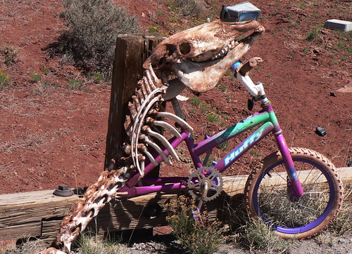
At Mesita, we started an “Explorer’s Option” that was fabulous. Ten miles of riding the old road with just one pickup truck along the way. We saw more old bridges, an unidentified snake, and a weird assemblage of two broken children’s bicycles and the skull and spine of a horse. This was one of the strangest things I’d ever seen on a bike ride, but I later found out it was the work of Leon and not some Indian shaman.
Lon was encouraged to see that several bicycles tracks were visible in the sand that occasionally covered the pavement. He’s concerned that some people are skipping the sightseeing and exploring aspects of this trip and treating it like a regular Pac Tour where you just concentrate on getting to the next motel as quickly as possible. “All these hammerheads…” he grumbled. “We don’t hammer, Lon,” said Anurang. “Just mallet.”
This part of the road was actually much more ridable than any of us remembered from five years previous. There had been much more sand then; it was almost as though someone had swept the road clear.
When we finally emerged from the optional route, the sag truck was waiting for us with food and water, along with Gavin and Rhona towing their trailers. Now came a long series of rolling climbs first on I-40 and then (after a bit of fence hopping) on a frontage road to get us to our lunch stop at mile 62.5. This was at a giant truck stop/Indian casino, the name of which escapes me now, but I think you can catch Howie Mandel or The Fabulous Thunderbirds there.
At the Roadrunner Café, a modern 50’s themed restaurant, they even let me plug in my bike computer to get the battery charged up enough to last the rest of the ride.
After lunch, one long, shallow climb on both I-40 and a frontage road (no hopping required this time), which Lon, Anurang, Franz, Gavin and Rhona and I all did pretty much together.
That was followed by a quick, straight descent down Central Avenue right into Albuquerque. Both Anurang and I got up to about 40 miles an hour briefly. “First time this trip, dude!”
Traffic was hellacious in the city, but we fortunately didn’t have too far to go before crossing the Rio Grande and finding our motel.
I felt the best I have physically for some time; my knees certainly feel better than last night. Let’s hope the trend continues.
Day 10: Holbrook, AZ to Gallup, NM
Distance: 62 miles
Climbing: 1,500 feet

For more photos, be sure to check Flickr.
The only thing that sucks more than headwind is having Microsoft Word crash after you’ve been typing for half an hour. Which it just did here at the Grants Laundromat.
Anyhow, as I was saying (pause while I save), we had a great wireless connection in the lobby of the fabulous El Rancho hotel last night, so I managed to get caught up a bit. It was quite a sight at 9:00 or so, with half a dozen Pac Tour riders sitting in the ranch-style armchairs in the lobby with their laptops in front of them. I e-mailed Anurang two chairs down to let him know that I’d posted the day’s Flickr photos. I finished up by 11:00, but I think Lynette was out there until 1:00 or so.
The next morning, I checked my tires and discovered that the front had gone soft, although not completely deflated, during the night. So I took it off the bike and went out to sit on the hotel’s porch to fix it. A Japanese tourist came out to take a picture of the hotel front and I could see him hesitate while deciding whether my presence would spoil his shot or not. He opted for a picture of the hotel with a cyclist fixing a bike wheel in front of it.
Mindful of the price I paid for not having found the guilty thorn in my front tire the first time a few days ago, I checked the tire inside and out. I could find nothing that might have caused a puncture. John Welch told me a technique that he had heard about, but never actually tried, that involves running a lady’s stocking along the inside of the tire on the theory that the stocking will snag on things that your finger might not feel. Alas, I packed no lady’s stocking on this particular trip. So, I went ahead and replaced the tube and hoped for the best.
After a pancake breakfast, I was ready for a “rest” day of just 62 miles with a slow climb to the Continental Divide followed by a mostly downhill run to Grants. I decided that one good way to pace myself would be to stick with Anurang for the duration of the climb, and that’s exactly what I did. It took about two hours to get there, and about half of the climb was on the interstate again.
When we got to the rest stop at the Continental Divide, we reconnected with Rhona and Gavin, the Scottish cyclists who are 11 months into a 12-month trip around most of the world for charity. That was great because it gave Lon the opportunity to give them the spare route cards that he’d found for them.
Anurang, Lon, and I left the rest stop at the Divide together with the Scots, and we headed for Grants on the frontage road. Here’s the strange thing: yesterday we were essentially climbing all day and feeling like we were descending because of the tailwind we had. Today, we were pretty much descending all day, but having to work hard to do it, as the wind got progressively worse. Some of the time, I rode behind Lon and Gavin, who were discovering mutual acquaintances and discussing all sorts of things I couldn’t really hear over the wind. Other times, I rode with Anurang and Rhona, who were keeping a slightly more reasonable pace.
Anurang told me later that we rode this same stretch five years ago 50 minutes faster (on the bike) than today. I believe it. Toward the end, it really felt like we were crawling. So much for a “rest” day. However, we did finally get in early enough to have time to eat a big lunch at the Grants Café with our new friends and to wash clothes in a real laundromat rather than in the sink.
(For lunch, I had some pretty spicy cheese enchiladas. Lon ordered a bowl of chili. After it came and he took one bite, he called the waitress back and asked if he could please have a cheeseburger. I don’t think they make the chili quite that hot in Wisconsin.)
After getting back from the laundromat, I offered to let Gavin and Rhona check their e-mail et cetera on my laptop while I got my stuff sorted out. It was nice to have an excuse not to be writing this, so I got out my Route 66 ukulele and noodled for a bit. Next thing I knew, it was time for dinner.
Ride. Eat. Eat. Ride. Such is our life. This time, we walked a hundred yards farther to a place called El Cafecito or something like that. I had some New Mexico-style burritos to complement my earlier enchiladas. I have also become addicted to sopapillas with honey. Rhona and Gavin joined us and we heard more about their travels and talked about all kinds of stuff cycling-related and otherwise.
Day 9: Holbrook, AZ to Gallup, NM
Distance: 100 miles
Climbing: 3,100 feet
For more photos, be sure to check Flickr.

What a great day! This was one of the most fun days we had on our trip five years ago, but today was even better. For one thing, the wind finally shifted to the west, which meant it was giving us a good push all day long. That went a long way toward making me feel as though I’m finally getting stronger and riding better, although my aching knees this evening tell a slightly different story.
My alarm went off at 5:00 am because we planned to head off for breakfast around 6:00. It takes me about an hour to get everything together each morning and figure out how to get it all back into the Pac Tour bag. Plus, there were the last ten minutes of this classic Twilight Zone episode with one of the Darrens from Bewitched, you know, the one who was also in the movie about the Scopes trial. Honestly, I was just trying to find the Weather Channel.
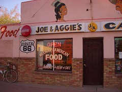
Anurang and I rode the three quarters of a mile down the road to Joe and Aggie’s, where we had a fair breakfast but enjoyed great service. Although I ate French toast, two eggs, and two good-sized sausage patties (and a banana when I first got up in my wigwam), I was still hungry all morning long.
Rollout was at 7:30, and the wind was helpful right off the bat. We started toward the back of the pack and enjoyed the easy pedaling after a longish shallow climb out of town. After four miles, we had to get on the interstate. Lon got a bit irked when some riders ahead of us skipped the first option at mile 18, which was actually a very nice frontage road. It did dead end at a junkyard though, where we had to jump a fence to get back onto I-40. The fence wasn’t too bad, but the “goathead” thorns all around it were nasty.
After a few more miles we got off the interstate again at the exit for Petrified Forest National Park, which also was our first rest stop. The next dirt option starts inside the Park ($5 per bike entry fee) and is one of the highlights of the whole trip, in my opinion. There is still old pavement, but there is also a lot of sand. Very quickly, you find yourself in what seems like the middle of nowhere. It’s hard to believe that thousands of cars used to travel this route until you step a few feet into the desert and see all the old tin cans.

This is also one of the longer “off-road” options, lasting about 12 or 13 miles. We tried to stay in small groups as that made it easier to get over the few fences that we had to hop along the way. I concentrated on trying to relax and let my bike find its way through the sandy bits. It’s still a little unnerving when I feel the wheels slipping beneath me, but so far so good.
I found some reading glasses on the road and stopped to scoop them up, figuring there was a good chance they belonged to one of our riders. We have a lot of people on this tour who need reading glasses, yours truly included, although I’m fortunate that I can still read Pac Tour route sheets without them. When we got to Gallup, I found out that they belonged to Gerd.
A few more miles on the interstate took us to yet another nice frontage road. Frankly, I think old frontage roads are nice when you have a ripping tail wind. Even the interstate is nice under those circumstances.
Lunch was at the Sanders Diner, which is an original Valentines Diner. I didn’t see anyone in there except Navajos and Pac Tour riders. It’s in pretty decrepit shape, but it is for sale. Four of us started lunch a little after 1:00 and were finishing up around 2:00 when Anurang said something about how late we would be getting in to Gallup.
“If we ride well,” said Lon, “we should be in in two and a half hours.”
There was a pregnant pause as we all pondered what Lon meant by riding “well.”
“And what if we ride like we usually do?” I asked.
“Three hours.”

In fact, it took us just a little under three hours. Although we had to briefly get on the interstate again, most of our remaining miles were on frontage roads and Route 118 (into Gallup). Shortly after leaving lunch, the landscape started to seem more like New Mexico to me, with pinon pines and grass. Although it hardly felt like it with the tailwind, we were climbing pretty much all day, and the temperature was cool when you stopped and could feel the wind.
The sculpted cliffs on the side of the road were as impressive as I remembered from five years ago. We crossed the border into New Mexico and after passing many many motels and most of the town itself, found ourselves at the El Rancho.
The rooms in this hotel aren’t that much bigger (or more modern) than a wigwam, but the lobby is spectacular (it kind of reminds me of Will Rogers’s house). Will Rogers probably stayed here, along with most of the other great old movie stars. The rooms are named much more impressively than the ones in Seligman, although I have to admit that I’d never heard of the person whose name adorns my door: Zachary Scott.
Day 8: Flagstaff, AZ to Holbrook, AZ
Distance: 88 miles
Climbing: 3,451

This will probably have to be a short description of the day’s ride as I am back in a wigwam, and this wigwam is far more authentic than the ones in Rialto/San Bernardino. No wireless (working or otherwise), no Ethernet, no phone, and no grounded outlets. One difference between this MacBook Pro and our old PowerBook is that the AC adapter requires a three-pronged, grounded outlet.
Anyway, Anurang and I met at a little after 6:00 to go look for breakfast. First we tried the place that had been recommended, but after we’d been sitting for about 10 minutes without water, coffee or someone asking us what we wanted to eat, we realized that the single waitress and cook at this particular place were overwhelmed. Lon, sitting at the next booth, suggested that we try another place a little further down the road, so about eight of us decamped for that place, which was a much better situation with quick service and good food. It was called “The Place.”
I admit that I was a bit anxious to get on the road and start in on our 88 miles before the wind kicked up, as all the forecasts said it would. We rolled out of the motel parking lot at a bit past 7:30 and started out of Flagstaff, which was fairly pleasant as it was Sunday morning (or so I’m told), and we were already pretty much on the east side of town. It was chilly, but the skies were cloudless and the wind was actually helping us as we began gradually descending.
I quickly lost sight of Anurang but decided to just keep on going as there were lots of other riders around.
Almost as soon as you leave Flagstaff and get on I-40 to head east, the trees disappear and you are back in a more prairie/desert environment. I noticed a couple of semis parked by the on-ramp as we got on the interstate; in one of them I could see the driver sleeping with his head on the steering wheel.
This first interstate section went pretty quickly and I passed a few riders who had left ahead of me. Eventually, I saw another rider in my rear-view mirror and guessed correctly that it was Leon. He pulled up alongside me and we rode together past the Twin Arrows trading post (now deserted and apparently slated for a housing development) and the Diablo Canyon. Oh, and I forgot: Winona, although I don’t recall actually seeing anything there.
We stopped once to take pictures of the view back up the highway with the snow capped peak above Flagstaff visible.
After 35 miles, we reached the first rest stop, which was located just past a closed interstate rest stop. I remembered having a rest stop at this same spot five years ago, and it was a good deal more windy then. That’s not to say that we didn’t have wind, but I think that it was coming more from the southwest than directly from the south, so it wasn’t nearly as bad as it might have been. By this time, I was feeling somewhat sanguine about getting to Winslow on the early side for lunch.
Pulling out of the rest stop, we agreed that we would skip the first gravel option near Meteor City and concentrate on getting to Winslow by around 11:00 by sticking to I-40. The wind started to pick up, though, and depending on the terrain and our heading our speed varied wildly between 17 and 7 miles per hour. Most of the time, though, we made good progress.
In fact, we got to Winslow just a few minutes after 11, passing “the corner” with its statue of the guy and his guitar. The building that the accompanying mural is painted on burned down a few years ago, leaving only the exterior walls, so the park has been fenced off while they try to find money to repair it.

Our lunch was to be at La Posada, a restored Harvey House railroad hotel that truly is a marvel. This lunch was probably ten times nicer than any other we’ll have on this trip, and it was included in the tour (thanks Lon!). The hotel itself is a masterpiece of Spanish hacienda architecture, and I’d love to stay there sometime. It probably even has wireless. According to the brochure I grabbed, the restaurant’s menu features “Fred Harvey specialties and Native American inspired nouvelle cuisine.” I had duck confit. It had lots of beans and corn and other Native American inspired stuff with it. The lemonade was good, too. Leon had never had American-style lemonade before. In South Africa, lemonade is like Sprite (as it is in Britain).
Anurang showed up about half hour after us and also had the duck.
Leon and I finally left La Posada together while Anurang was tucking into a brownie dessert. The wind was still quite strong, but I felt good enough about our progress that I suggested we take the next optional detour. This was a lovely ten-mile section of old road that got us completely off the interstate. There was still a fair amount of pavement but also a lot of sand. Leon is a good mountain biker, so I tried to follow his lead. It was just enough sand to help build my confidence so that I don’t tense up every time the bike starts to do that sand shimmy thing. We saw no one else on the road at all, unless you count a trio of steers who jumped up and ran away at the sight of us.
Back onto the interstate and it was just a few miles to the Jack Rabbit Trading Post. I was going to say that this is a great place to buy a rubber tomahawk but, come to think of it, I didn’t see any rubber tomahawks. I’m pretty sure they had them five years ago, though. Regardless, they were nice folks. It’s clearly a family business. While we were there, Anurang showed up, so the three of us left together and began the final trip to Holbrook, which started with some nice frontage road and eventually landed us back on … the interstate. Before we got on, though, we made a pit stop at a truck stop, which necessitated a) weaving through a dozen semis waiting to buy gas and b) riding directly into the late-afternoon wind as we crossed back over the freeway. As I stood on my pedals, it occurred to me that it might have been the first time I’d ever had to do that while riding downhill.
When we got to Holbrook, I found that I had wigwam #1. On the way to dinner, Anurang and I met some Scottish cyclists who are going around the world from Perth (Scotland) to Perth (Australia) to Perth (Canada). Someone suggested that they use Route 66 to get across the western U.S. Here’s their website: http://perth2perth2perth.org/

Day 7: Seligman, AZ to Flagstaff, AZ
Distance: 82 miles
Climbing: 6,586
Well, this was a tough day. We had climbing, a stiff south wind, and our first serious off-road riding all conspiring to make this the longest day of the trip thus far. Add to that a few flat tires (two of them mine), and Anurang and I didn’t roll into the ironically named Luxury Inn until something like 5:30.
But to begin at the beginning – we had a great breakfast across the street at Lilo’s Café, before rolling out of Seligman on Rt 66 heading east. Most of the day, we were going some variation on east – I guess because Chicago is more or less east of Santa Monica. The wind was already strong when we started on this day, so we didn’t get any easy miles at all. Just a series of long gradual climbs with too much wind.
After about 11 miles, we reached the summit of the first ridge that we were climbing. Looking to the southeast, I could see two mountains; one fairly near and one pretty far with snow on it. The nearer one was near Williams, and the farther one was near Flagstaff. It looked a long ways away.

After 19 miles, we got on our first section of really old road that was closed to cars. This was kind of exciting, especially since the road itself was relatively ridable. I took lots of photos on this section, though I’m not sure they came out that well.
A rest stop waited for us at the end of this road, after which we rode through the town of Ashfork, which is where all the flagstone in America apparently comes from.
We then hopped back onto I-40 for a few miles before getting off to ride one of the old alignments. Don’t forget that we’re climbing all this time! This particular section starts out pretty easy (in terms of gravel) and gets progressively trickier. Eventually, it peters out and literally disappears under I-40. At that point, we squeezed through a barbed wire fence, very carefully crossed the freeway, and continued on I-40 East.

Getting off a few miles later at Devil Dog Road, we took a somewhat circuitous route to reach yet another section of very old alignment that has now become a gravel road. This was probably the toughest riding of the whole day. It climbed on loose gravel and took a lot of energy. Again, we dead ended at I-40, but this time we didn’t have to cross the freeway to continue east.
From here, fortunately, it was mostly downhill to Williams, where we had lunch at the excellent Twister’s Café. Great milkshakes.
By now it was clear that things were running a bit behind schedule, and I think it’s fair to say that the culprit was the wind. In general, I think I had a false impression of how easy this trip would be – based on the conditions that we had five years ago. This time around, the wind and the heat are much worse. I, of course, am convinced this is all because of global warming. But still, it’s kind of a drag to take two hours longer to do the same ride and to be as tired as if you were actually on a “real” Pac Tour. Oh well, if I get really trashed, I suppose I can take a rest day somewhere.
After lunch, I hung back a bit with Anurang as we… climbed some more. And we weren’t done with either the dirt or the interstate, either. The next section of old road was partially paved and partially sand/gravel. It’s also where I had to fix my two flat tires. I should have found the thorn the first time. Oh well, lesson learned, I hope.
Eventually, we got back on I-40 for a long (I’ve been using that word a lot, haven’t I?) trip up to the Arizona divide. That’s when things finally started to get a bit easier as we descended to Flagstaff and then rode through town with a detour though Northern Arizona University to miss the worst traffic.
Chinese food for dinner, and now I must stop typing and try to get some sleep. Tomorrow offers a lot less climbing (and a lot more descending), but I hear that the wind may actually be worse.
Day 6: Kingman, AZ to Seligman, AZ
Distance: 88 miles
Climbing: 3,879
On John Muir’s birthday, we departed Kingman at a bit past 8:00 after scarfing down a complimentary breakfast buffet at the Quality Inn. Few natural forces in the universe are capable of wreaking havoc on a buffet like a bunch of Pac Tour riders almost one week into their trip. Fortunately, this is a smallish group for Pac Tour, so there were a few donuts and toaster waffles left over for the truckers.
After the heat of yesterday afternoon, everyone seemed relieved that skies were cloudier and temperatures were cooler on this morning. Anurang and I were just about the last to leave, and we set off with Lon and Jim Meyers (who is also doing some blogging). It didn’t take us long to catch up to some of the other riders, though, as we wound our way through some major road work in Kingman.
We were stopped at a traffic light when the window rolled down on a pickup truck to my left and the passenger asked me a question I didn’t quite catch. It sounded to me like the guy had an accent, too. “Excuse me?” I said.
“Do you have any grey poupon?” he asked again.
“Non,” I replied.
They laughed and the guy then said, “You guys are crazy. You’re going to get hit.”
“Oh no,” I said. “We’re taking the old road.” And then the light changed.
Well, in fact, the old road wasn’t that old today. We could occasionally see it off to one side of the highway we were on, but it was on what is now private property, and it didn’t look particularly ridable at that. This road was a real highway – not an interstate, though – with a reasonably good if somewhat gravelly shoulder and variable traffic that included a fair number of trucks. If a truck passed us while someone else was approaching in the opposite lane, though, our shoulder started to feel a little less roomy.
Looking at my route card now, I see that there is not a single turn on it for the 88 miles from Kingman to Seligman. In fact, the road builders did their best to make sure that there were as few curves as possible. This road sometimes ran for more than ten miles straight as telephone line, and it occasionally became frustrating as we pedaled and pedaled and could scarcely tell whether we were making any progress or not. The high-desert scenery, although not quite as bleak as, say, West Texas, didn’t offer a whole lot to look at after you admired the mesas and hills at the far end of the road.

At least there were some interesting stops to break up the monotony. After a pretty fast 12 tailwind-powered miles, we took a photo at mile marker 66, which we had also done five years ago. A further 14 miles up the road was a nice souvenir shop in Hackberry, were I picked up an aloha (Hawaiian) shirt with a Route 66 theme that I can wear to my ukulele group.
Somewhere between Hackberry and a SAG stop at Peach Springs, another rider apparently accidentally brushed wheels with Leon and, as he fell down, something on his bike ripped into the Leon’s rear wheel and took out four spokes, as well as disabling the freewheel. They waited 15 minutes before a group of riders that included Lon came along, and Lon swapped rear wheels with Leon. Of course since Lon rides a single-speed bike, that meant that Leon had only three gears (I’m assuming he could still use his front derailleur) to ride the four or five miles to the rest stop (not a problem for Leon, I suspect, as he seems to be a very strong rider). Lon then rode that section on Leon’s rear wheel (after truing it as best as possible with several spokes missing from the same section). Lon was lucky and the wheel didn’t disintegrate. I should have taken a picture of it, as we were at the rest stop when he arrived.
By now the wind was becoming stronger but not necessarily favorable. When the wind’s that strong, it has to be right at your back, or it just slows you down. We also had a fair amount of climbing to do at this point; our lunch stop at Grand Canyon Caverns was at 5,450 feet – more than 2,000 feet higher than Hackberry.
I had forgotten that Grand Canyon Caverns, and the restaurant adjoining, are at least a mile (up and into the wind) off the highway. By the time we go there, I was ready for something to eat, having only had a banana, a coke, an ice cream bar, beef jerky, a package of cookies and, uh, probably some other stuff, to sustain me since breakfast. The interior of the place always reminds me of the National Park Service’s cafeteria in North by Northwest. I think we slightly overwhelmed them, but eventually I was able to get a grilled chicken sandwich.
From the Caverns, it was only 27 miles to Seligman, but the wind was pretty bad, and at least 12 of these miles were across one of those giant valleys where the road starts to feel like a treadmill as the mountain never gets any closer. Except that it did eventually get close enough that we had to turn to get around it, which meant heading straight into the wind for the first time all day.
This was a good time to be riding behind Lon.
However, the ride ended with a four-mile downhill into town, which is always welcome, even when the wind keeps you from doing it at 30 miles an hour.
As soon as we’d stashed our gear bags in our rooms, Anurang and I headed over to the Snow Cap to have an ice cream cone and marvel at the schtick they’re famous for. (Ask for a shake, and he’ll offer you his hand; ask for a cone, and you’ll get a traffic cone, etc). How they keep from getting jaded, I don’t know. Must be something to do with living in a small town that’s 80 miles from anywhere and a mile and a half from the interstate. Seligman could have become a ghost town just like so many of the others we’ve seen on this trip, but Angel Delgadillo (a barber) and his late brother Juan (owner and builder of the Snow Cap) made sure that it didn’t.
Anurang went over to Angel’s barbershop to see if he could get a shave (well, it’s really 80% souvenir shop at this point), but the barber had left for the day – he’s semi-retired, after all.
Dinner tonight was at “The Road Kill” diner – their motto: “You kill it; we grill it.” Since I haven’t killed anything lately, I had a Philly cheese steak sandwich.
Don’t know whether I’ll be able to get on-line and post this tonight; the phones are a bit funky at this authentic, historic Route 66 motel, which, as near as I can tell is named “Historic Route 66 Motel.” They have plaques on most of the doors denoting a famous person who has slept there. I was thrilled five years ago to have the room that Will Rogers, Jr. once slept in. (I actually met the man once; his father is a hero of mine.) This time I got the second-coolest (in my opinion) room: Bobby Troup’s.
