Archive for the ‘Uncategorized’ Category
Day 23: Carthage, MO to Strafford, MO
Distance: 87 miles
Climbing: 3,100 feet

For more photos, be sure to check Flickr.
It would not be an exaggeration to say that I was not looking forward to today. This “three-day rain event” is really bad timing. And of course, there has been a drought here all spring, so I really can’t begrudge them the rain, but even the local forecasters seem to think it may be too much of a good thing.
Carthage seemed like an interesting place. Did you know that the first major land engagement of the Civil War happened there? There also is a large and imposing gothic county courthouse. Tim Arnold and I got a close-up look at it on our way back from Braum’s ice cream after dinner last night.
I had a big breakfast (two orders of French toast) on the theory that if it did rain it would be that much harder to eat on the bike. It wasn’t raining when I went to breakfast in town, nor when I came back. But by the time we were supposed to load our bags on the trailers, it was starting to shower. I actually was kind of glad, because it meant I didn’t have to wonder whether I should put on my rain pants or not at the start. I hate the rain pants, but I hate stopping to put them on in mid ride even more.
I rode all the way to the first rest stop with Franz and Gerd at a fairly easy pace. Lon had us riding on farm roads insstead of Route 66 because Rt. 96 (which used to be 66) has lots of truck traffic. This part of the ride was absolutely lovely and rural, with lots of farm fields and dogs who would half-heartedly come out to bark at us but not really be into giving serious chase. I chatted quite a bit with Gerd and even asked Franz whether he was experiencing any tiredness on the ride (no, he is not). He really is an excellent cyclist. At dinner tonight, I learned that he and his wife do track stands when they have to stop on their tandem.
I stopped just before the first rest stop to put the hood on my jacket up. The showers seemed to come and go all through these 30 miles, but they seemed to be coming harder. Gerd and Franz rode ahead around a corner. Then, through “operator error,” I rode right past the rest stop at a Baptist church, even though I saw the church and knew that the stop was at a church. I realized my mistake fairly quickly, though, when I got to a long straight stretch and saw no sign of Franz and Gerd.
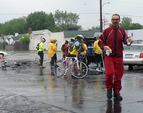
I doubled back to the church, where Rosemary had parked her SUV under a driveway awning. Minutes after I pulled in, the rain started coming down harder. Lon and Susan’s group pulled in a few minutes later, and the heavens opened up. It was really raining now, and folks were happy to accept the hospitality of the Baptists, who let us use their restrooms and stand in their foyer trying to keep warm. More than one person was eyeing the church’s school bus fleet as well, wondering how many cyclists one of them could hold.
I was just resigning myself to leaving and heading back out into the thunderstorm, when I realized that Lon was showing no sign of wanting to decamp. I took this as a sign that it might be better to wait. Sure enough, when Lon finally did decide to leave, it was while it was still raining, but the worst was over and things gradually improved for the rest of the day. Franz and Gerd had left earlier and spent 20 minutes in what Franz described as “sheer hell.”
Alas, I was a little slow getting out of the church (last-minute bathroom stop), and Lon and Susan’s group had almost a minute head start on me. I half-heartedly started to chase them but quickly realized that it would be a poor use of energy that I might need later. So I rode the next stretch almost completely by myself. This was when the real Missouri “rollers” started: those series of straight, short, steep hills like the back of an asphalt sea monster. As I would start one set of rollers, I’d see the group ahead of me disappearing over the top of the last hill ahead of me.
My cyclometer got all messed up by the rain (waterproof, right…), so I was extra careful to make sure that I got each turn right, and sightings of the group ahead of me were reassuring. Eventually, I realized that I was coming up to another rest stop and assumed (correctly) that I’d be able to join the group ahead of me there if I was a little quicker when Lon put on his helmet.
From that stop we rode through more of the same kind of farmlands and hills, until we crossed over I-44 at mile 67, after which we were heading into Springfield. We rode right through downtown Springfield (this is the only PAC Tour where you actually go through cities like Santa Fe, Albuquerque, Amarillo, Tulsa, and Springfield; usually PAC Tours avoid all cities as much as possible). Before we got out of town, we stopped at a Steak and Shake that Lon believes is the original Steak and Shake from 1932. Lon and I did some malted milkshake research there.
Lots of Route 66 business and references in Springfield.
From lunch, it was only 13 miles to our motel, and the weather was actually nice at this point. I had taken all my rain gear off at mile 50.
Nice modern motel with high-speed wireless Internet access, so maybe I can get caught up with my photos tonight, too. I need to hurry, though, because tomorrow promises to be a challenging day – with more weather and more miles.
Day 22: Vinita, OK to Carthage, MO
Distance: 106 miles
Climbing: 2,200 feet
I like this motel. It has a full-sized public laundromat right on the premises. Give me a clean, non-smoking room with a bathtub, and I’m a happy camper. The only thing it’s missing is wireless Internet, but I can at least dial in with the modem, which was impossible a couple of nights ago.
We road in three states today, but the scenery didn’t change much from yesterday that I could tell. Still lots of agriculture, green fields, horses, trees (including pecan trees), and lots of dogs. The last few days have been rife with dogs. Besides the little guy who joined the peloton for at least a mile in downtown Tulsa yesterday, my favorite was a beautiful border collie who jumped off his front porch as I went by and just ran alongside me in the grass for a few hundred yards. He must have thought I was some kind of exotic sheep. No barking – just a happy run.
We’ve also been seeing some wildlife – as well as a lot of roadkill. The unfortunates seem to be mostly armadillos, but some turtles and possums have also been spotted, including one mother possum whose babies were crawling all over her (I didn’t see that myself; maybe it’s an urban legend).
But I also rode a fair bit with Jim Hlavka and Reed Finfrock, and they’re both good at identifying all the birds that crossed our path (scissortail fly catchers, meadowlarks, killdeers, etc), and Jim and I both saw a woodchuck scampering into the undergrowth. I don’t think I’ve ever seen a woodchuck before. I thought it might be a beaver at first. I’m such a city boy.
The weather was overcast for the most part, but no one was complaining after yesterday’s deluge. Unfortunately, the forecast for the next couple of days is not good. Lots of rain. The big question is how much of it will happen while we’re riding. I think it’s a certainty that we’ll get pretty wet, but it’s not supposed to be cold, so that will help somewhat. And tomorrow is a relatively short day (followed by two long ones), and the wind is supposed to shift to the south, which is an improvement in the grand scheme of things.
So, I’m trying to think positively. This is a vacation after all, at least in theory. The truth is, though, that I’m ready to be home sleeping in my own bed. Riding through two to three inches of rain in Missouri is just something I have to get through before I can do that.
Day 21: Bristow, OK to Vinita, OK
Miles: 104
Climbing: 2,800 feet
Dark.
Pancakes.
Cold.
Pottery factory.
Wet.
Tulsa.
Tour de Tulsa.
Little black dog running after us for two miles with tongue hanging out.
Tulsa
Wet.
Famous Blue Whale.
Wet.
Claremore, OK. Dot’s diner. Custard pie.
Wet.
Green.
Wet.
Horses.
Wet.
Vinita, OK.
Bad Chinese food.

Day 20: Oklahoma City, OK to Bristow, OK
Distance: 91 miles
Climbing: 4,000 feet

Not sure what to say about today. Weatherwise, it was a carbon copy of yesterday: cool bordering on cold in the morning and warm and muggy by late afternoon. If we’d had a tailwind, I probably would have been too warm in my long-sleeved jersey, but it was a light headwind all the way.
As we move eastward in Oklahoma, the terrain is getting a bit hillier, as the climbing numbers indicate. There aren’t any big hills, just lots of little ones.
Most of the time, I didn’t feel like I was riding on Route 66. Leaving Oklahoma City, we parted ways with our old friend I-40 and are now paralleling I-44 northeastward toward St. Louis. However, Route 66 doesn’t seem to be in use as a frontage road for the Interstate as much as it was in western Oklahoma. So we are riding on secondary roads that follow the same route that 66 did, with the old road occasionally visible in the weeds and trees on either side of us.
I started out riding with Lon, Susan Notorangelo, Franz, and Jim Hlavka; we took a different route than the one that Lon had on the route card because Jim Ross, who was our special guest at dinner last night, had suggested an alternate way to get out of Oklahoma City that would be less traffic and possibly include more of historic 66. Lon wanted to try this route out, so we did a bit of exploring of some of the nicer parts of Oklahoma City, including a 1930s historic neighborhood with many Arts and Crafts bungalows.
Eventually, we reconnected with the official route and shortly afterward stopped at the Round Barn, which is a large wooden barn (round, naturally) that was been meticulously restored by a crew of senior citizen volunteers who called themselves “The Over the Hill Gang.” The acoustics were extraordinary.
The rest of the ride was pretty uneventful: very rural with lots of trees, hills, horses, dogs, and a fair amount of traffic. I am still feeling a bit tired from yesterday and from the 1,000-plus miles I’ve already ridden, and Chicago seems like it’s still a long ways away. Missouri is just a couple of days away, and I know that the rolling hills there are going to hurt, but I’ve been through much of that part of the route before, so I reckon I can get through it again.
One nice thing is that Susan Notorangelo is riding with us from here to St. Louis, and having her on the trip is bound to make it more fun. Let’s see: about two more days of Oklahoma, four of Missouri, and about three of Illinois to go….
P.S. There doesn’t seem to be any way to get an Internet connection here in Bristow, so I won’t be posting this until tomorrow at the earliest.
Day 19: Clinton, OK to Oklahoma City, OK
Distance: 94 miles
Climbing: 3,500 feet

I expected this to be a tough day, but it ended up being tough for entirely different reasons than the one I was worried about. The weather wasn’t exactly balmy, but that wasn’t what made the day hard at all.
Last night, a big thunderstorm moved through Clinton (and the rest of western Oklahoma, I expect) around midnight. So, we got lucky and missed the heavy rain completely.
At breakfast, I was happy to see Oklahoma resident and native Don Norvelle (and his wife Evelyn), who Lon had asked to scout out the Bridgeport option to see if the Canadian River might be fordable by bicycle. Don didn’t seem to think the option was a good idea, so Lon reluctantly canceled it.
Although there was no immediate sign of rain, people seemed to be in a hurry to get going this morning – even Lon, who usually is among the last to leave. Although I was a bit more optimistic about the rain forecast, there still was a headwind to contend with. I got with a medium-sized group that had Lon and Franz at the front breaking the wind, and then we quickly passed a couple of earlier groups that had left ahead of us.
I think we were the first riders to reach the first rest stop at an abandoned gas station at mile 24. I was impressed at the quick progress we were making despite the headwind, and cold, overcast skies.
As it was a windy day, it was appropriate that we passed a wind farm with gigantic windmills. They looked huge from the road, but when we passed a windmill arm on the ground in the town of Weatherford, I realized that a single arm was big enough for someone to live in. It was bigger than a whale, which is the only thing I can think of to compare it to.
Ten miles after that rest stop, we came to what was supposed to be the turnoff for the Bridgeport option.
I should explain just a little about Bridgeport. Back before Route 66, someone names Keyes built a big suspension bridge across the Canadian River and put a toll booth at one end. Because this was the only good crossing of the river for miles (maybe 50 miles?), his family made a pretty good living off of it. For complicated reasons that I’m too tired to go into now, it was acquired by the state shortly after it became Route 66, and it was bypassed in favor of a different route and new bridge shortly after it was acquired by the state (which meant the end of Bridgeport as a viable town). The road there, before, during and after its tenure as 66, was never paved. In the fifties, the bridge caught fire (it was a plank bridge), and it was ultimately torn down for scrap. All that remains are the pilings at either end – kind of as if the Golden Gate bridge were all gone except for the north and south towers.
Don now seemed to offer some hope that the road wasn’t too muddy for cycling, so Lon decided that he wanted to do the Bridgeport option after all. Who wanted to go with him? I think almost everyone in our little group opted to go. I wasn’t thrilled about the possibility of riding through mud with my road fenders on my bike, but how could I miss what might turn out to be a great adventure.
For the record, here are the proud, the few, and the foolhardy who did this option:
Tim and Vicky Arnold
Franz Neuer
Reed Finfrock
Leon Van Zweel
Lon Haldeman
Me
Don led us down the first part of the road with his van so we wouldn’t get lost. He pulled up in front of a farmhouse where a gate led to a field. We stopped while Lon got more directions from Don. I felt something wet on my ankle and looked down: It was puppies. Several farm puppies were curious about where the heck we were going.

We were going across the pasture. This was a bit different than our previous pasture excursion a couple of days ago because the sand was wet and somewhat hard-packed. It was ridable.
We got down to somewhere near the river and got confused. Lon and a couple of other guys headed north to see if the river looked fordable while the rest of us waited for Don to follow us on foot.
The river was not fordable. “You could float a hippo,” said Lon. I guess the thunderstorm had done its work. Don came by and showed us where the old pilings were. They were quite large. This was a substantial bridge – and now it is just these incongruous poles sticking up in the bottomland between the pasture and the river. The area was heavily wooded, and Tim Arnold was kind enough to point out that it was also rife with poison oak.
OK, said Lon, we’ll just go across on the railroad trestle. The trestle was just a couple of hundred yards downstream from the site of the toll bridge. According to Lon’s route sheet, “the railroad bridge is very seldom used.”
I wondered if the definition of “seldom used” was as open to interpretation as “riding well.” Did it mean one train a day? One a week? One a decade?
We got back up to the trestle bridge fairly easily by way of the pasture.
It looked long.
Reed said he’d already been across it and back again while were waiting for Don and examining the bridge pilings and “it held my weight, so it ought to hold yours.” Off we went. The bridge seemed even longer. There was just one set of tracks and not much in the way of options should a train happen by. I looked down between the ties I was stepping on to see how far down the river looked.
That was a mistake.
Some of the ties looked pretty rotten, but they mostly seemed well supported by ironwork below. I tried to pick less-rotten ones to step on.
OK, so far this was all interesting and somewhat exciting, but once I got across to the other side, the hard part started. The “road” here was just wet sand, basically, and it didn’t take long before it was clear that my fenders were going to be a handicap. The mud just completely clogged up between the tire and the fender so that it was like I was riding with the brakes on – especially on hills. And this part of Oklahoma has hills.
By the time we finally made it to pavement, I was exhausted from trying (unsuccessfully) to keep up. I was also hungrier and thirstier than I should have been. By my reckoning, we had added almost 10 miles to our 84 mile day.
I was glad to be back on the pavement, but the endless rollers (“Oklahoma is like Missouri without the trees,” said Lon, which I think is unfair – there just aren’t as many trees. It looks sylvan compared with the Caprock in Texas).
Fortunately, Lon decided that we should stop for lunch at a Cherokee Truck Stop, so I got a chance to rest a bit and eat some food, although I think I was still running an energy deficit. Once we were back on the road, I continued to struggle, feeling like I was holding the group back. Reed hadn’t stopped with us for lunch, so now we were down to six.
Somehow I made it through the next forty miles, the last ten of which were pretty flat thank goodness. The funny thing is that I had started the day feeling the best I have for a while – I just left all that energy behind in the Bridgeport mud.
Day 18: Shamrock, TX to Clinton, OK
Distance: 82 miles
Climbing: 1,600 feet

For more photos, be sure to check Flickr.
What’s the first thing Anurang does when he gets back to San Francisco? He sends me an e-mail with a copy of the weather forecast for today. Hazardous weather, that is. He knows how I love to panic about stuff like that.
However, I already knew that the forecast was bad, and I had already prepared by getting my fenders out of the storage for spare tires and spending half an hour putting them on my bike (I also changed my rear tire, just to be extra safe). Now, if putting a rain jacket on can forestall the rain for a couple of hours, putting fenders on the bike is enough to guarantee at least one really nice (if somewhat humid) day.
And that’s what we got.
Don’t worry, though – I’m still panicked, because the forecast for tomorrow is even worse than today’s was. And I don’t think the fender voodoo is good for more than one day.

Still, let’s focus on the positive: Today was great. The wind was pretty strong right from the start, but as it was coming from the southwest, and we were heading mostly east, it gave us a good push. I had a quick ride with a group that included the Arnolds, John Welch, Jim Meyers, and Lon almost to the Oklahoma border (Lon dropped back to fix something with his wheel, possibly a leaky tube). After stopping for a quick picture at the border (I’ve never entered Oklahoma on a bike before), we rolled into the town of Erick, where we were greeted by Harley and Annabelle Russell of the Sand Hill Curiosity Shop.
This was quite a treat. Harley used to play guitar for Charley Pride and others but has retired to his hometown where he and Annabelle peform for Route 66 tourists in their shop, which has almost nothing for sale but is crammed with memorabilia and cool guitars. I asked about his Roy Smeck signature Gibson (only 52 made) and he also pointed out a rare Martin signed by Mike Longworth among others. Harley didn’t know that Mike had died, though. No ukuleles in the “shop,” either.
He can really play, too. I took a Quicktime movie with my camera and, if I’m feeling ambitious may try to upload some of it. They gave us coffecake, juice, maracas, and tambourines and performed part of their “Mediocre Music” show, which mainly consisted of “The Wabash Cannonball” and “Get Your Kicks on Route 66”.
After this, I rode with Franz for quite a bit. He’s a strong rider and I had to work a bit to keep up with him (or at least not slow him down too much). We chatted about how beautiful Oklahoma is and how cool the road itself is.
Very soon, we were on one of Lon’s favorite sections of the historic concrete pavement. This part is closed to cars and quite overgrown with trees. Unlike the parts of Texas we’ve been through, this part of Oklahoma has lots of trees. Also, many wildflowers, horses, and whimsical mailboxes. Best of all, it’s very green. Hard to imagine what it must have been like during the Dust Bowl era.
The trees section was interesting (though I had to walk a few parts because it was just too overgrown), but what I really admired were the sections that have been keep just as they were in the 30’s (beautifully done concrete with gently rounded curbs) that now function as frontage to I-40 (which we never had to ride on at all today). I can’t decided whether it reminds me more of a nicely shaped French pastry crust or like a Hot Wheels track. And the red Oklahoma dirt gives it a slight reddish tinge. I asked Franz, and he said it was kind of… taupe. I’ll have to take his word for it.
As we crested one hill today, both Franz and I were struck by how damned beautiful the landscape was. Who knew Oklahoma was so pretty?
I visited two different Route 66 museums today, too. One was in Elk City, and is a sort of commercial venture. I didn’t care for it too much. The other is here in Clinton and is run by the state of Oklahoma. It was a lot more interesting for me, with a lot of information on how the road was constructed, among other things.
Thanks to the helpful winds, Franz and I actually beat the van/trailer to the motel today, which is a first for me in 9,000 miles of PAC tour riding. So we went and checked out the Clinton Route 66 museum rather than wait around. I figured I’d better go to both museums because I knew what the first thing Lon would ask me would be when I saw him at the motel:
“Did you go the museum?”
I had the right answer.
Day 17: Amarillo, TX to Shamrock, TX
Distance: 98 miles
Climbing: 1,400 feet

Successfully doing a PAC Tour, even a Route 66 PAC Tour, requires some time-management skills. I need to work on that. I’m just getting started with this and it’s already past when I should be going to bed.
Breakfast at the Big Texan restaurant and then out through Amarillo east toward Shamrock. This is our only full day of riding in Texas. Yesterday we started in New Mexico and tomorrow we will mostly be in Oklahoma.
While we were still on the Caprock, the terrain was pretty dull, and the wind was blowing steadily from the southwest. Just flat, flat brown stuff.
After 25 miles, we reached the town of Conway or at least the rest stop just outside the town of Conway. I was the only person who took the route card literally and detoured half a mile to the site of the Conway Café. I wasn’t sure what to expect, but I got the Bug Ranch – a sort of miniature Cadillac Ranch done with Volkswagens. Well, it was worth the extra mile, but it meant I had to work a bit to catch back up to the main group, which for most of the day included Lon, Tim and Vicky Arnold, and John Welch.
Another 16 miles or so took us to the town of Groom, which seems to be famous for a giant cross “largest in the western hemisphere and a Spiritual Experience” according to the signage. It’s also where you’ll find the Blessed Mary Café, which is a pretty bare bones place that is more like a shrine to the Catholic Church than an actual eatery — lots of pictures of Popes and, especially, Mother Theresa. It’s probably the only Route 66 Café that doesn’t have pictures of Elvis and Marilyn, in fact. Lon loves that the menu has no prices – you just drop whatever you think you owe into a jar by the door. I had a couple of pieces of pie and an iced tea. The second piece wasn’t very good, but it didn’t cost me much.
Then it was past the famous leaning water tower of Groom, TX, and onto the infamous Jericho Gap.
When I first heard of the Jericho Gap I pictured some narrow rocky canyon kind of like New Mexico’s Big Notch. Actually, it was a gap in the paved portion of the original alignment of Route 66. Until a more modern alignment came along, the Gap was just a series of dirt farm roads strung together.
It still is to this day.
Lon told us how farmers used to make some extra money by pulling cars out of the notorious mud holes of the Jericho gap with their tractors. Then, at night, they would go freshen up the holes.
We started on gravel, and it wasn’t too bad at first. At one point, we did end up on some pavement, but that was short-lived. We also visited an impressive, modern rest stop on I-40 that had a Route 66 theme. In the town of Old Jericho, all that was left were a decaying motel in the middle of nowhere (well, in the middle of a farm field in the middle of nowhere), and a cemetery that I didn’t even notice, although a mile later there was a historical marker about it. We poked around the motel ruins and also admired a large, beautiful, dead rattlesnake. It looked as though someone had killed it with a rock.
The second portion of the Gap (after the brief paved section) was where we descended from the Caprock plateau, and where the trail became considerably sandier. At one point, we reached a fence with a crude gate where Lon believed that the old road paralleled some railroad tracks. I know that Lon had never ridden that section before, and I don’t think he intended that we should either. Susan Rosenblatt said, “Why don’t we try it?” though, and you could see Lon’s face light up.
It wasn’t a piece of cake, but there was plenty of pie – cow pies. It also was a bit sandy in spots, but not as sandy as the last few miles of the Gap, which saw me convinced on at least one occasion that I was going down for the count. Somehow, the bike righted itself at the last possible second. I had thought I was getting better at the sandy stuff, but this was the most challenging extended section like this so far on the trip, and I realized that I still have a long way to go. Plus, riding in that stuff is tiring!
Finally, we got back on pavement, much to my relief, and stopped for lunch at a cowboy steakhouse – the kind of place that has different animal heads mounted on the rafters in ascending order of size. After almost 25 miles of old road, dirt, gravel, and sand, I was ready for a cheeseburger. Some of the other riders, who had opted not to do Jericho Gap, were already finishing up when we entered the restaurant. “Well, that took about an hour and a half longer than I thought it would,” said Lon of our Jericho Gap expedition. That was partly, I think, because it was harder than expected and because we had to stop on a couple of occasions to fix flat tires.
As we came out the steakhouse, it was clear that the weather had changed dramatically. It was past 3:30 now, and the sky was dark as a bruise to the southwest. Lightning flashed. Thunder boomed. “Well, we have a four-mile head start,” said Lon, after counting the seconds between the two. Shamrock, our destination for the day, was still 20 miles away. I didn’t ask how fast a Texas thunderstorm travels. We jumped on our bikes and hightailed it.
Fortunately, I think the wind was helping us more than hurting us at this point, and Shamrock was also slightly downhill from where we were starting. Still, our speed seemed to vary between 15 and 20 mph. At one point, I decided in a selfless act of heroism to put on my rainjacket, thereby virtually guaranteeing that we would beat the rain in, but also forcing me to work hard for a few miles to catch back up to the pack (and getting me somewhat overheated in the process).
By the time we crossed the Shamrock city limits, the storm was spitting droplets, but the pavement was still dry. I felt like it might let loose at any minute, but in fact things didn’t really go crazy until a little less than an hour after we got in. I heard that the very last riders to make it in beat the deluge by just a matter of minutes.
I checked the forecast for tomorrow, and it isn’t very good, so I put fenders on my bike as well as changed my rear tire. It’s supposed to be a really pretty and interesting day of cycling – I don’t want to let the weather spoil it.
Day 16: Tucumcari, NM to Amarillo, TX
Distance: 124 miles
Climbing: 3,500 feet

For more photos, be sure to check Flickr.
The best laid plans of mice, men and bicyclists…
Things started out pretty well this morning, with Lon and Anurang on the tandem and light wind as we left Tucumcari. Almost all the day’s riding was on frontage roads to I-40 and, for about 18 miles, I-40 itself. Some of those frontage roads used to be 66, but it’s hard to tell unless you ask Lon.
By the time we reached the first rest stop, though, just across the Texas border, the wind was picking up. As we left that rest stop, it was the tandem followed by Jim Meyers, Jim Hlavka, and me. All the Jims. I noticed many wildflowers along the side of the road where it had been mown. I don’t know whether that was because they like the mowed terrain or someone seeded them — but they didn’t start showng up until we were in Texas.
Texas, this part of it, is flat, brown, and flat. Well, it actually wasn’t quite flat enough — we either seemed to be going uphill just enough to slow us down or downhill not enough to speed us up. And it especially wasn’t flat when we reached the Caprock Climb, which takes you up onto the plateau that we’ll be on top of until sometime tomorrow.
It was pretty obvious that Lon and Anurang were struggling in the wind and with the hills, however slight. Anurang was very uncomfortable on the bike, for some reason – I guess it just didn’t fit him right. This must be the kind of thing that doesn’t show up on a forty-mile spin with a raging tailwind. Today, the wind was from the north/northeast, and it was slowing everyone down. I don’t know when I’ve ever seen Lon work that hard. Possilby it was on Wide World of Sports more than 20 years ago. Afterward he said he felt like he’d done a 25-mile time trial.
As we started the climb up Caprock, I decided to go ahead, since we also were passing through an interstate construction zone. It just felt good to go at my own pace rather than wait behind the tandem, which was climbing slower than Lon would normally, but perhaps a bit faster than Anurang would normally. On the way, I passed Gavin and Rhona (the Scottish world travelers), who had started that morning from somewhere east of Tucumcari. I imagine they had a very long day trying to get to Amarillo.
It wasn’t very far from the summit of the Caprock climb to the Midpoint Café, which, supposedly, is halfway between L.A. and Chicago on Route 66. The other two Jims and the tandem pulled in just a few minutes after I did, and we all ate cheeseburgers. No milkshakes available, but they had pie.
To Lon’s relief, Anurang decided that he’d had enough, so Lon got his single bike back out to ride the remaining miles to Amarillo. Anurang got a ride in the van (well, he did ride exactly half of the complete Route 66 route). Jim Hlavka left ahead of us because he felt like it would be a good idea for him to ride a little harder at his own speed for awhile (we never caught him). Lon, Jim Meyers, and I all left more or less together (I had to catch up after waiting to take a quick picture at the midpoint marker), and started taking turns pedaling into the wind.
We maintained this three-man pacellne all the way to a Love’s Truck Stop, where we got some drinks and snacks to see us into Amarillo.
Getting through town took a long time, and I felt like I was having sensory overload after riding the first 100 miles through the plains. I lost count of the Route 66 signs. The west side of town seemed to be the funky side, but we had no time to stop and admire. Lon was on a mission to get to the Big Texan.
We finally rolled in to the finish at a few minutes past five o’clock, which means the whole ride took a bit more than 10 hours, including the hour for lunch.
Getting in to the Big Texan was a relief, but it’s not my favorite motel. It’s the ultimate in western/Texas kitsch, and the food is great if you like lukewarm meat. After getting cleaned up and checking e-mail, I went for dinner with the whole group and had some lukewarm ribs and a free beer.
Now, I’m bushed. In theory, tomorrow should be quite a bit easier, though, as the wind is supposed to be better and the distance is just under 100 miles.
Day 15: Santa Rosa, NM to Tucumcari, NM
Distance: 62 miles
Climbing: 1,900 feet

For more photos, be sure to check Flickr.
“At least it’s hump day,” said someone at breakfast this morning. Well, it’s true that we have only 14 days to go now, but I think the end seems near in more ways than that. Tomorrow is Anurang’s last day on the tour, for instance, and it will be completely different without him around. When we started, the number of cycling days seemed incomprehensible, and now only 14 are left. Before I know it, there will be fewer than ten, and then we’ll be down to less than a week with Chicago looming ever closer.
By then, though, I’ll be getting excited about seeing my home and family again.
But now I’m sitting in my all-time favorite motel on Route 66: The Blue Swallow of Tucumcari. I think I could live here quite comfortably. This town seems quiet and sleepy (and hot) on a Sunday afternoon, but it looks like a good life, and the Blue Swallow is such a lovely place. I can’t wait to see it tonight with the neon swallows lit up.
Physically, I feel the best that I have since the trip began. In fact, ever since that one good night of sleep in Las Vegas, I’ve felt great. Of course, it could be the last two days of tailwinds. Tomorrow the wind is supposed to change and we will have a real distance to ride (120 miles) through some flat, harsh and (frankly) boring countryside.
Getting back to today, Lon, Anurang, Jim Meyers, Reed Finfrock, and I rode first to the famous Blue Hole of Santa Rosa, which is a natural spring that also happens to be the only place where you can get certified as a scuba diver for hundreds of miles. People come from Colorado, I heard, to get their certification there. I suppose it’s booked pretty much solid for diving, and there were at least three groups of divers in it when we stopped by. Reed, who is a wonderful resource when it comes to anything natural history related, pointed out an invasive exotic plant (the name escapes me now) that the city of Santa Rosa really ought to try to extirpate from its perch on the lip of the Blue Hole.
After that, we climbed what Jim Meyers told me the locals call “Suicide Hill,” a little grade under the interstate, before following Route 84 to a frontage road. The day was already becoming warm. The frontage road turned into a long straight climb that Lon’s route card described as “steep.” When Lon puts “steep” on a route card, you’d better pay attention. Jim, Anurang, and I had fallen quite a bit behind Reed and Lon (taking off warm clothes and attending to other personal matters). I could see Lon and Reed a mile or two ahead on the climb as it got steeper and curved off to the right, but they were just two dots that hardly seemed to be moving at all. It was like watching the minute hand on a clock.
I decided to speed up a bit and left Anurang and Jim behind on the climb. When I got to the top, Reed and Lon were still just two dots, but now they were heading down an even longer, shallow descent – still perfectly straight. I figured they weren’t riding very hard, and since Lon was riding his single speed, I had enough of a slight advantage on that terrain that I might be able to catch up to them. That took about five minutes.
Did I mention that our promised western tailwind was blowing strongly? I know I’ll look back at today wistfully at some point during the next two weeks – perhaps as soon as tomorrow.
Not too long after I caught up to Lon and Reed (they really weren’t going very fast at all), we reached the turnoff for the Cuervo Cut-off. This is an old alignment of Route 66 that shaved off some miles from the very first route but was abandoned when a new alignment was laid out in 1952 (where the present-day I-40 is). It was paved, but the asphalt survives only sporadically where truck tires have kept the weeds down. Once it was twenty feet wide; today it’s just two strips of asphalt for truck tires. It rolls up and down some hills and dumps you out next to the interstate after seven miles.
We waited for Jim and Anurang (not far behind) before venturing onto the cut-off. It was a blast and in better shape than I remembered from five years ago, when I rode it alone with Lon after we’d messed around for an hour in Santa Rosa looking for an old alignment that probably had long ago vanished beneath the airport. I thought I was doing a lot better with my descending this time – almost keeping up with Lon, when I heard a “woo-woo-woo” from behind me and Anurang went blasting by both Lon and me. I guess he’s found his dirt legs.
During Cuervo, we caught up with a few riders who’d left ahead of us and, after finishing the cut-off, were back on the frontage road with the big tailwind at our back again.
Lon and I wound up ahead of the others at this point and I broached the idea of Anurang and me trying to ride Lon’s “Twin Air” Bike Friday tandem the next day on our long ride to Amarillo. He seemed initially receptive to the idea, but then started having second thoughts since the tandem has brand new wheels and Anurang has never captained a tandem before. I didn’t think that I was up to captaining with Anurang as the stoker, so I suggested that maybe Lon and Anurang could ride the tandem the next day, and I would just follow along behind them.
At the first rest stop, at mile 27, Lon suggested that he and Anurang try riding the tandem the rest of the way to Tucumcari. That meant changing the pedals and finding a bigger seat post and so on, which took about ten minutes. Then we set off.
I kept close as Lon explained the basics of tandem riding to Anurang. This was great for me, as it amounted to a master class in tandem riding. Sample exchange:
Anurang: “How do I know if I’m working hard enough?”
Lon: “If you… can talk… and I… can’t… you aren’t… working hard enough.”
Anurang loves to talk, so this could be interesting.
I was afraid that they might go so fast that I wouldn’t be able to keep up, but with a lot of spinning, both Jim Meyers and I managed to hold their wheel all the way to Tucumcari. It wasn’t even easy to follow them on the short climbs; they went at least 14 mph on them. I think this may have been one of the few times on the tour when Lon really had to put in some effort since he’s usually trying to slow himself down to our pace.
After we got to Tucumcari and had showers and lunch (we went to Kicks on 66, which was a good burger place and will hopefully also be a good breakfast place), we had a tour of the new murals that artists Doug and Sharon Quarles have painted around town, both inside and outside. Doug and Sharon led us all over downtown Tucumcari on their cruiser bikes, talking about each of the murals. These were fantastic and reminded me a lot of the Duboce Bikeway mural in San Francisco. Almost all the murals contain life-sized depictions of real people and wildlife from this area, and the backgrounds usually show real geographical features as well. My favorites were twin murals on either side of the interior of Lena’s Café. The café is closed on Sundays, but Lena herself met us to let us in for a look. The typical luncheonette booths are set away from the walls so that you can see the murals better (and probably to keep salsa and scrambled eggs off of them, too).
It’s twilight now and the neon signs at the Blue Swallow have been lit for a few minutes. I’ve already downloaded my photos for today, but I’ll take a couple of pictures tonight and upload them tomorrow if all goes well.
With 120 miles to do tomorrow and no more tailwind in the forecast, my plan is to follow “Team Lonurang” on the tandem if at all possible. Lon thinks they can cover the distance in about eight and a half hours of riding time, with an hour for lunch.
